Projects
The HMCS Canada Expedition 2025 is committed to engaging the public and inspiring a deeper understanding of Canada’s naval heritage and the marine sciences of the Florida Keys National Marine Sanctuary. Key outreach initiatives include
These efforts aim to make the expedition accessible and impactful for both local and international communities.

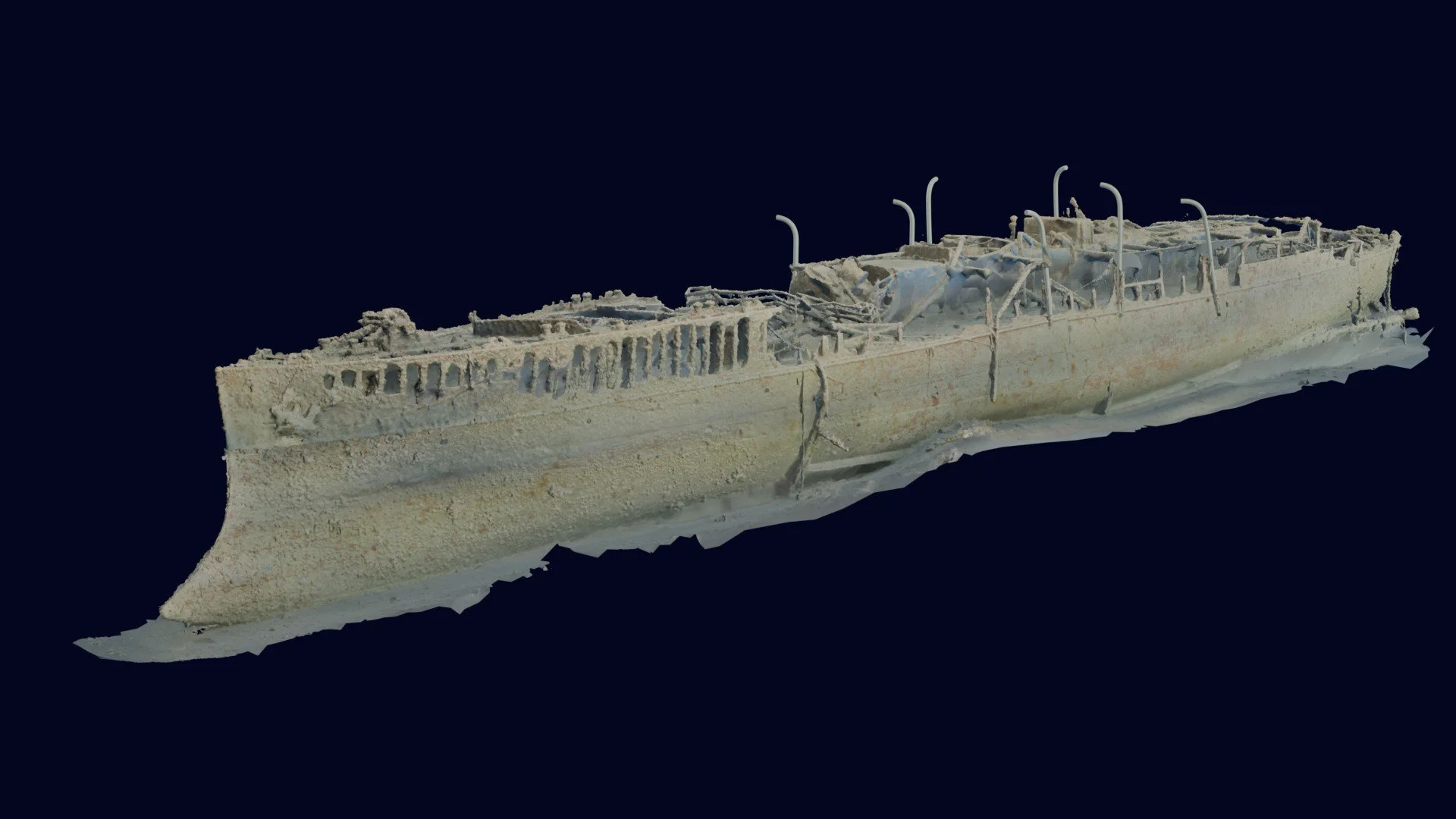
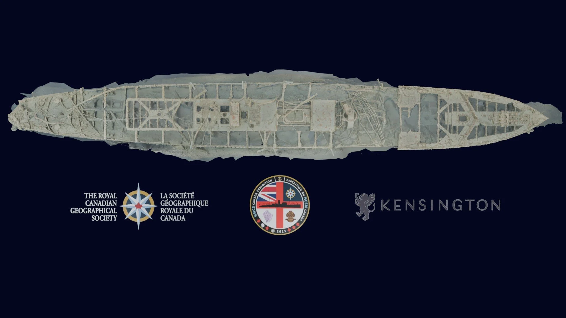
Photogrammetry Model (Completed).
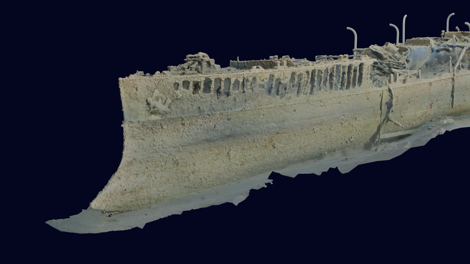
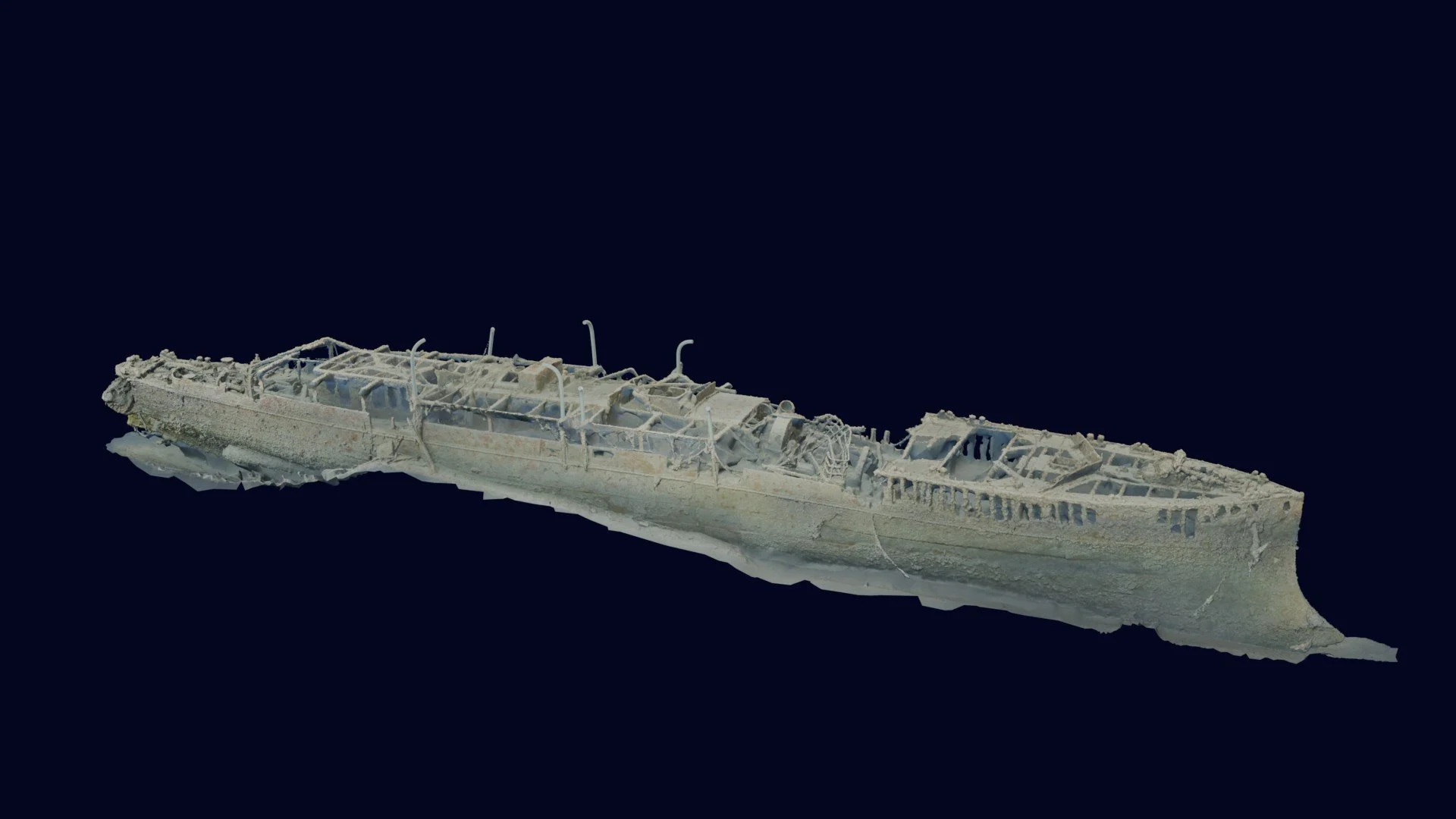
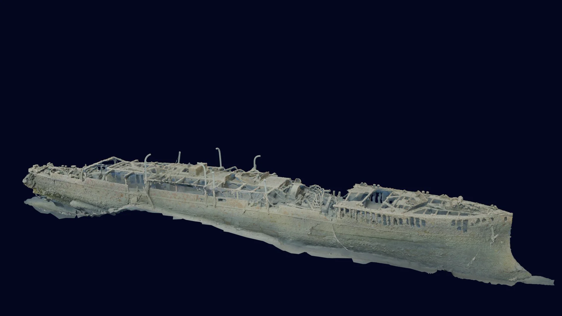
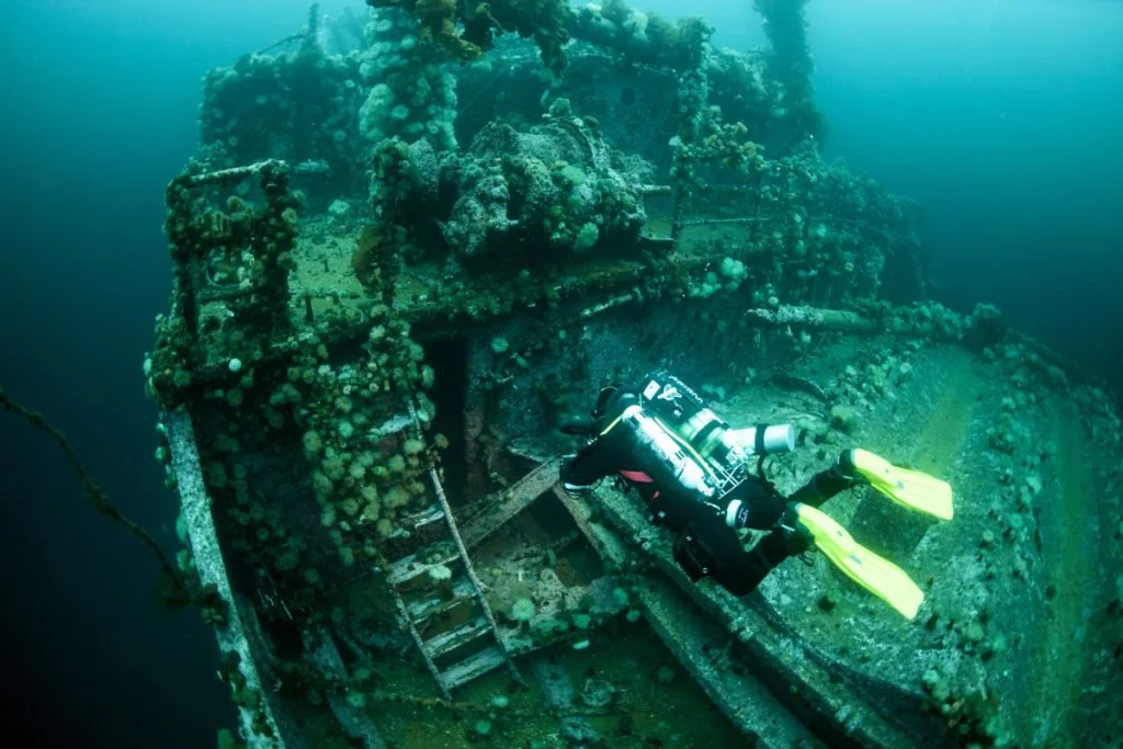
The completed 3D photogrammetry model of HMCS Canada is the centerpiece of the HMCS Canada Expedition’s scientific, educational, and public-engagement objectives. Produced through high-resolution diver-based photogrammetry, the model provides a detailed and immersive digital record of the wreck site as it exists today.
The model:
Is hosted online as an interactive experience, allowing viewers to explore the wreck site virtually from multiple perspectives.
Includes detailed annotations identifying key structural features of the vessel.
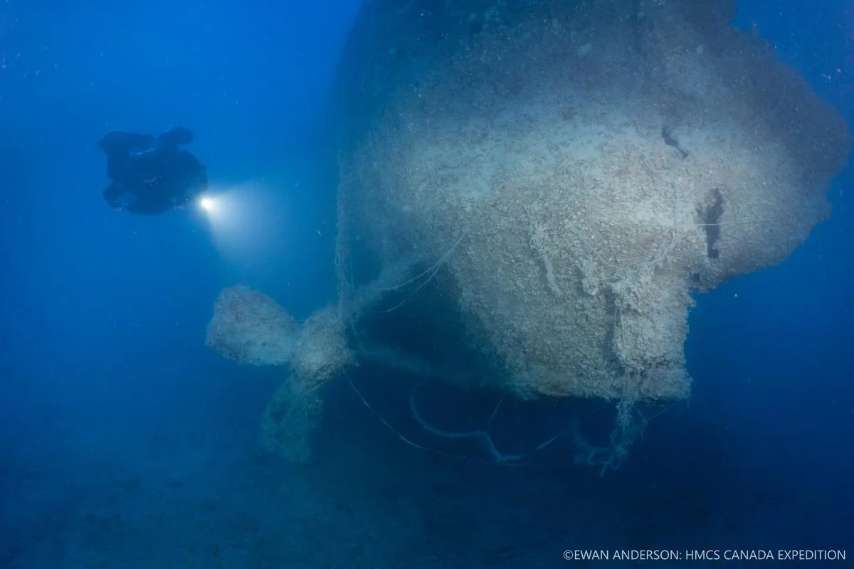
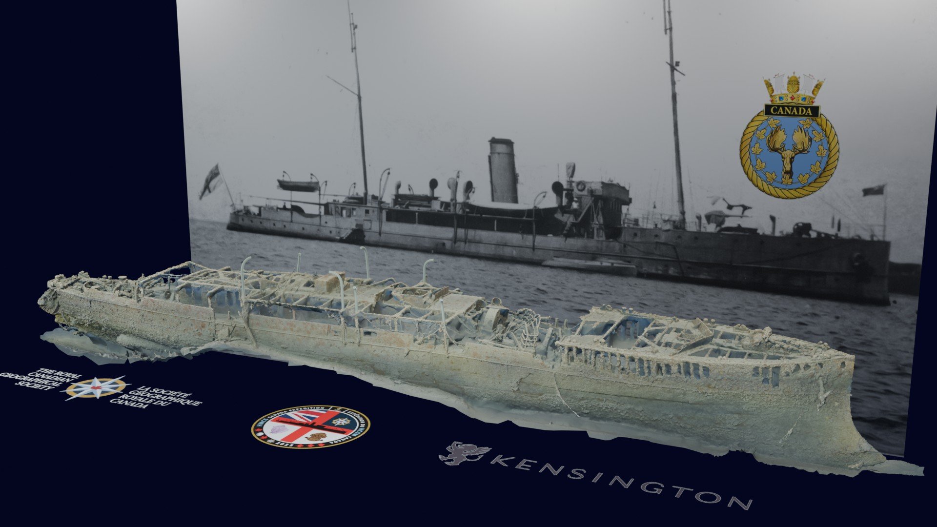
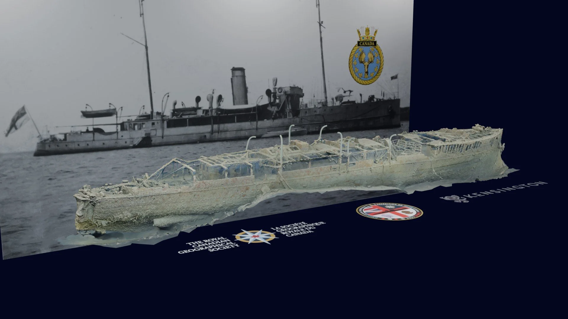
Documents the ship’s distinctive ram bow, a defining feature that helped confirm the wreck’s identity as HMCS Canada—the only sea-going warship of its kind ever built.
Reveals the absence of the starboard-side propeller, likely a contributing factor in the ship’s sinking, and allows direct comparison with the intact port-side propeller and propeller shaft.
Serves as a permanent digital resource for researchers, educators, heritage professionals, and the general public.
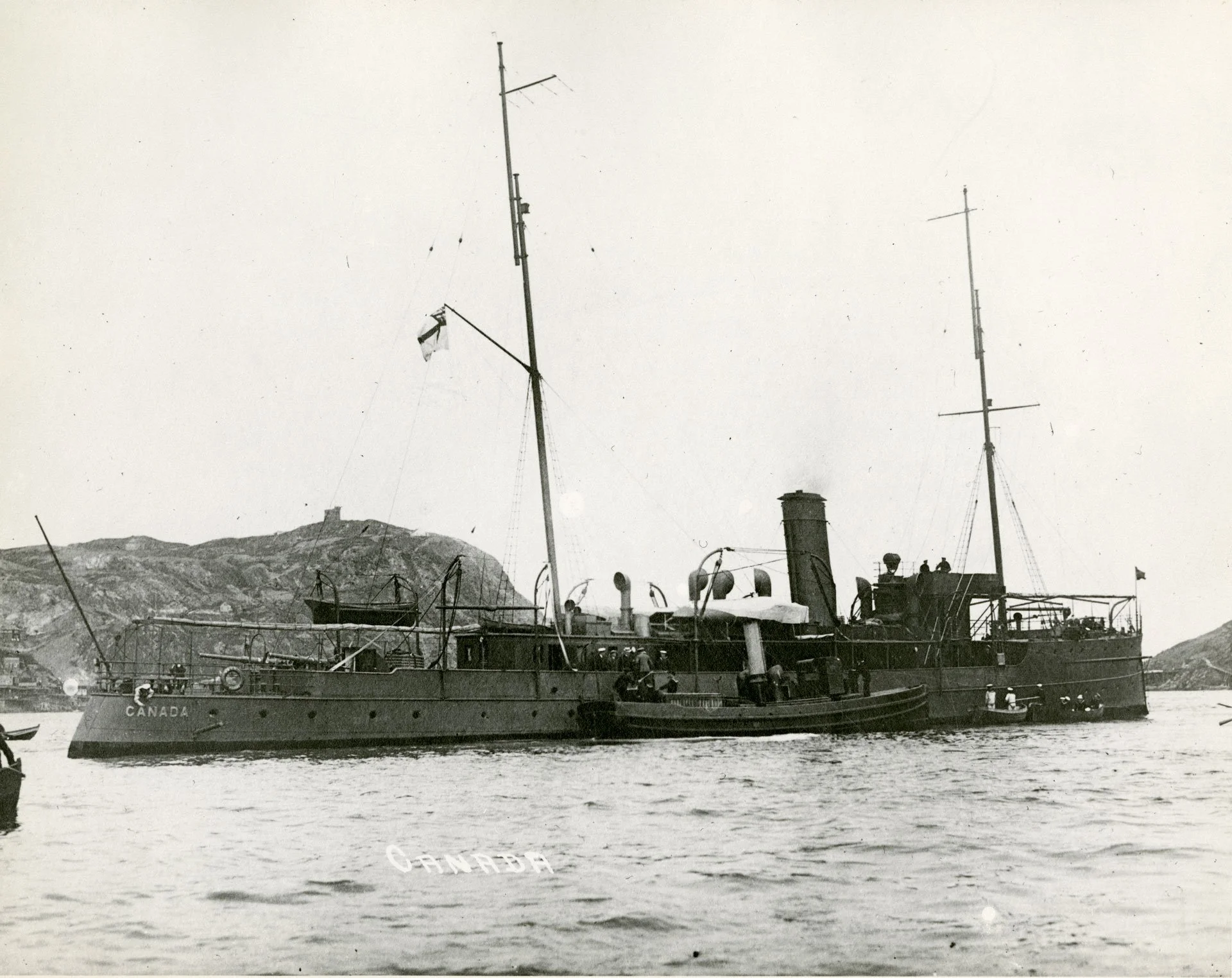
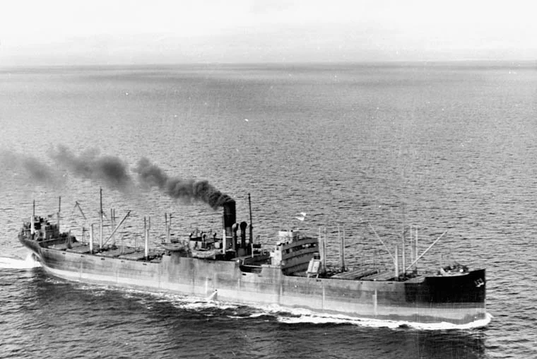
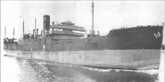
Our expedition’s 3D photogrammetry model represents the first comprehensive three-dimensional documentation of HMCS Canada and forms a lasting scientific and commemorative record of Canada’s first purpose-built warship, the only ship of her kind ever built, and the only surviving underwater hull of a Canadian First World War commissioned warship. Commissioned in 1904 for the Department of Marine and Fisheries as Canadian Government Ship (CGS) Canada, she was armed with four Mark III 1½-pounder quick-firing guns mounted on the main deck—two forward and two aft. With a complement of approximately 75 officers and men, she served on fisheries patrol duties and as a naval training vessel. In design and capability, she closely resembled a Royal Navy armed third-class cruiser. Canada underwent major armament and seakeeping upgrades in 1912, when her fo’c’sle was raised to improve performance in heavy seas and she was up armed with four 3-pounder guns. During the First World War she was transferred to the Royal Canadian Navy in 1915 and became His Majesty’s Canadian Ship (HMCS) Canada. Between 1915 and 1916, she received further naval artillery upgrades as part of her transition into frontline service and was up armed with two 12-pounder guns forward and retained two 3-pounders aft. During the war she served as both a training vessel and a convoy escort, protecting merchant shipping against German submarine threats. In 1917 she became the RCN’s second flagship and, in the same year, survived the Halifax Explosion—the largest man-made, non-nuclear explosion in history. HMCS Canada was paid off (decommissioned) in November 1919.
In 1924, the ship was sold to American businessman Barron Gift Collier and renamed SS Canada, later SS Queen of Nassau, entering first-class passenger service between Miami and Nassau. In 1926, she was sold to Mexican commercial interests who planned to place her in service between Tampico and New Orleans. In July 1926, she pulled anchor in Miami and steamed toward Tampa for final inspection prior to entering that service. Approximately 80 kilometres (50 miles) south of Miami, flooding was reported in her lower compartments; after an hour and a half battling the incoming water, the captain ordered the crew to abandon ship. She sank off the Florida Keys on July 2, 1926.
Expedition Video and Photographs (Completed)
This section presents a curated gallery of high-quality photographs and video recorded during the HMCS Canada Expedition. Together, these visual records document the expedition’s scientific work, operational challenges, and historical discoveries, and provide visual context for the completed 3D photogrammetry model.
All images and videos are fully captioned and credited, drawing from the expedition’s official photo and video documentation
The gallery includes:
-
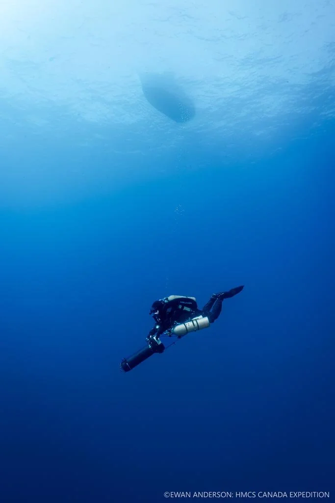
High-resolution photographs and video footage of the wreck of HMCS Canada, including the bow, stern, propulsion components, debris field, and surrounding marine life, recorded at depths exceeding 60 metres (200 feet). -
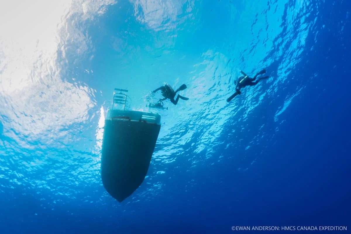
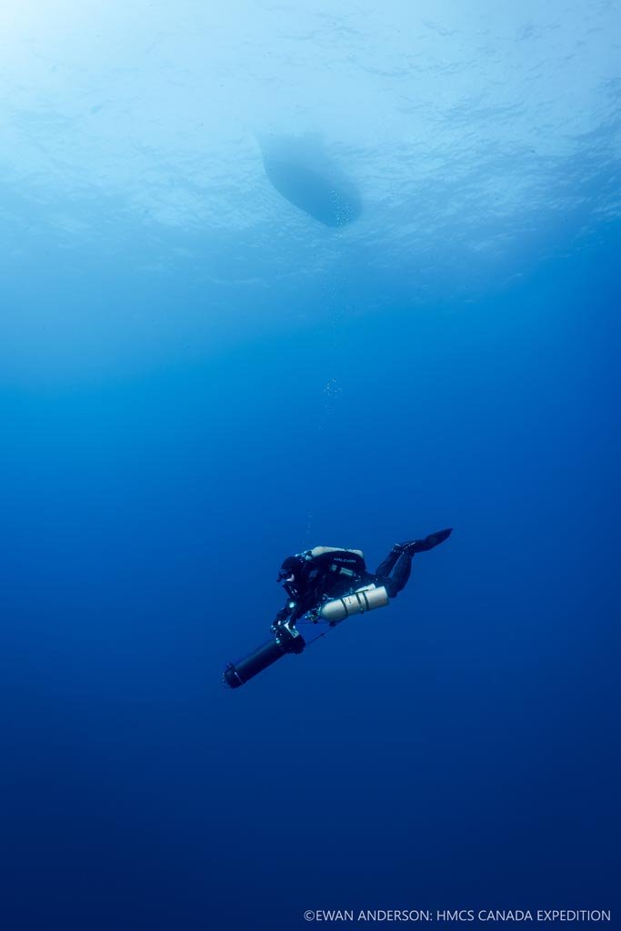
Behind-the-scenes imagery documenting technical diving operations, equipment staging, vessel operations, and diver deployment, illustrating the complexity and risk inherent in deep-water wreck documentation.
-
Visual records showing the deployment of camera and lighting sleds, diver-based data acquisition, and the direct link between in-water documentation and the completed 3D photogrammetry model.
-
Selected composite images and visual comparisons integrating archival photographs of HMCS Canada with modern expedition imagery and photogrammetry outputs, allowing viewers to compare the ship’s historical appearance with its present-day condition on the seafloor.
This photographic and video archive forms a permanent visual record of the expedition and supports ongoing research, education, public outreach, and heritage commemoration related to Canada’s first purpose-built warship.
Expedition Photographs
Diver Jason Cook relaxes during decompression at 15 m (50 feet) below the dive vessel, the 30-foot Island Hopper Pisces.

Diver Jason Cook unfurls the expedition’s Royal Canadian Navy ensign beneath the bow and port anchor of HMCS Canada, commemorating the Navy’s 115th anniversary. This may represent the first time an RCN ensign has been flown or displayed in association with Canada since the ship was paid off (decommissioned) in 1919.
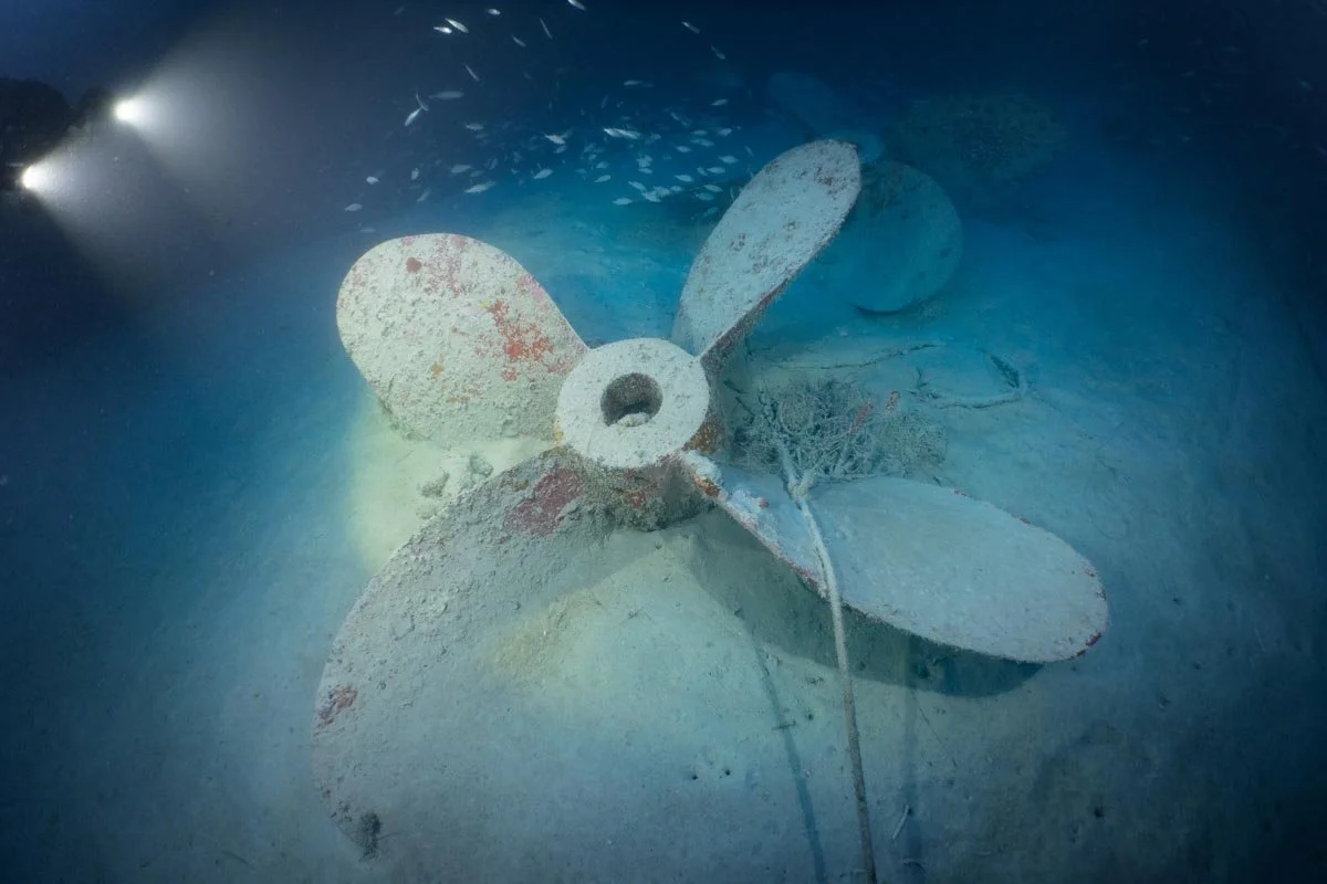
One of two spare propellers, entangled with modern anchor rope, resting on the seafloor at 69 m (225 feet) near the stern of the wreck.
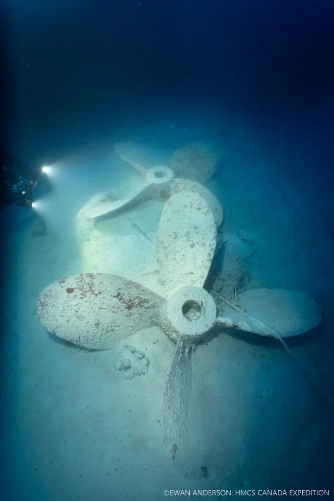
Two spare propellers resting on the seafloor at 69 m (225 feet) near the stern of the wreck site. A modern boat anchor, chain, rope, and fishing line are entangled around the heavy propellers.
Divers Roger Lacasse and Kelvin Davidson returning to the 30-foot Island Hopper Pisces at the conclusion of a dive.
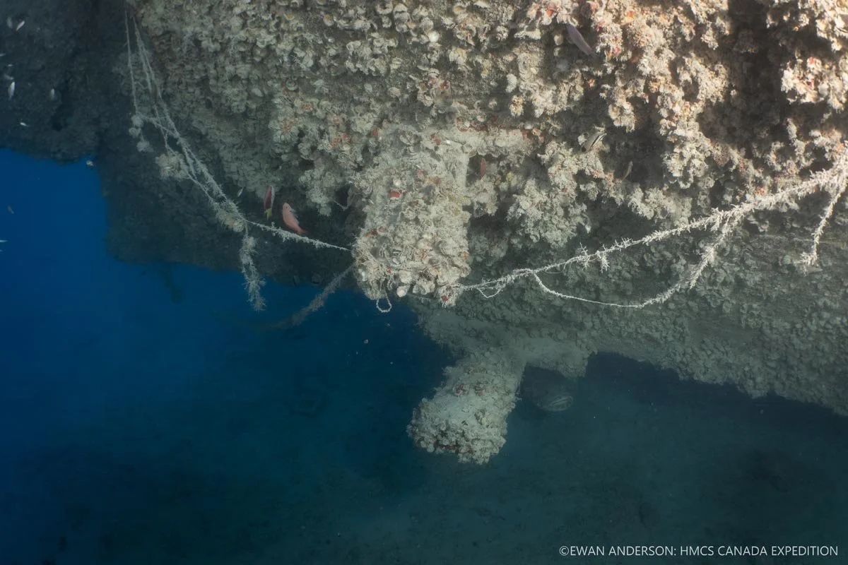
Detail view of the anchor windlass on the foredeck of HMCS Canada under artificial illumination.
Diver Jason Cook illuminates the anchor windlass on the foredeck of HMCS Canada.
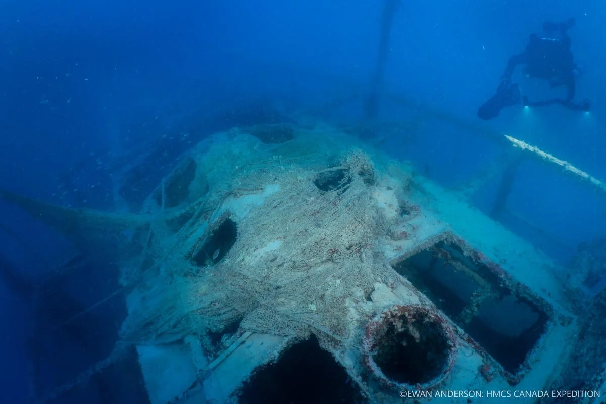
A decaying fishing net, entangled on the wreck for more than a quarter century, still covers part of the engine-room roof and skylights.
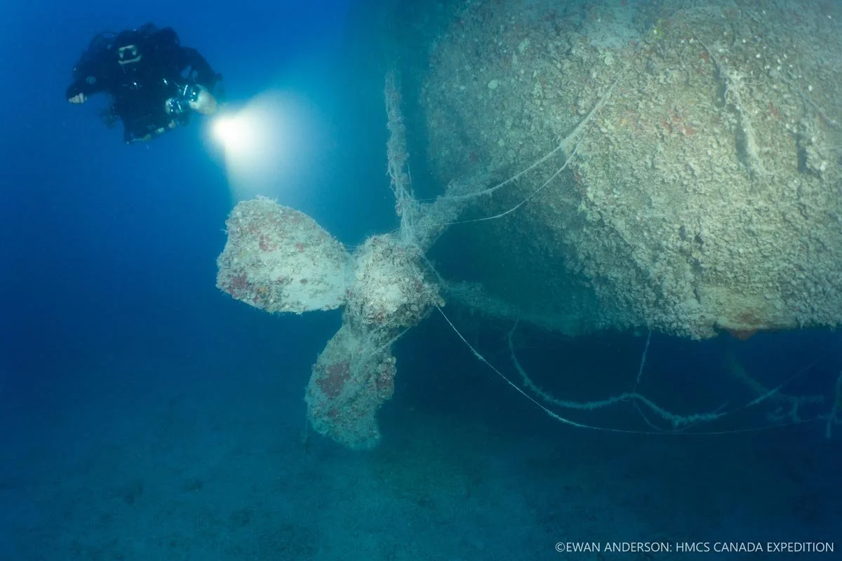
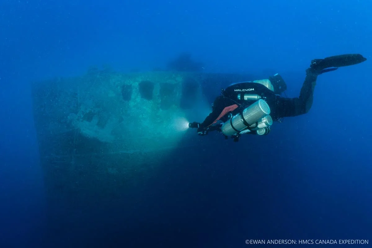
Diver Jason Cook illuminates the port-side propeller of HMCS Canada at 67 m (220 feet).
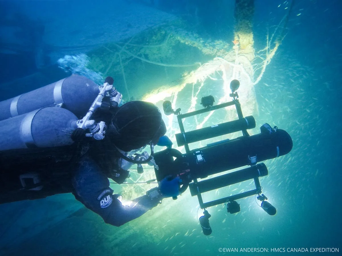
Photogrammetry specialist and expedition diver Roger Lacasse deploys a camera-and-lighting sled to document the wreck site.
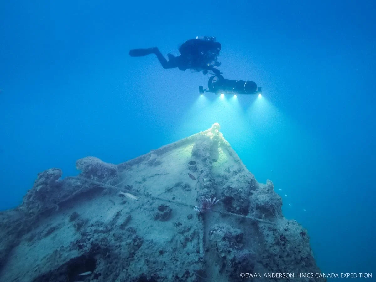
Roger Lacasse uses the photogrammetry sled to capture imagery of the bow of HMCS Canada at a depth exceeding 60 m (200 feet).

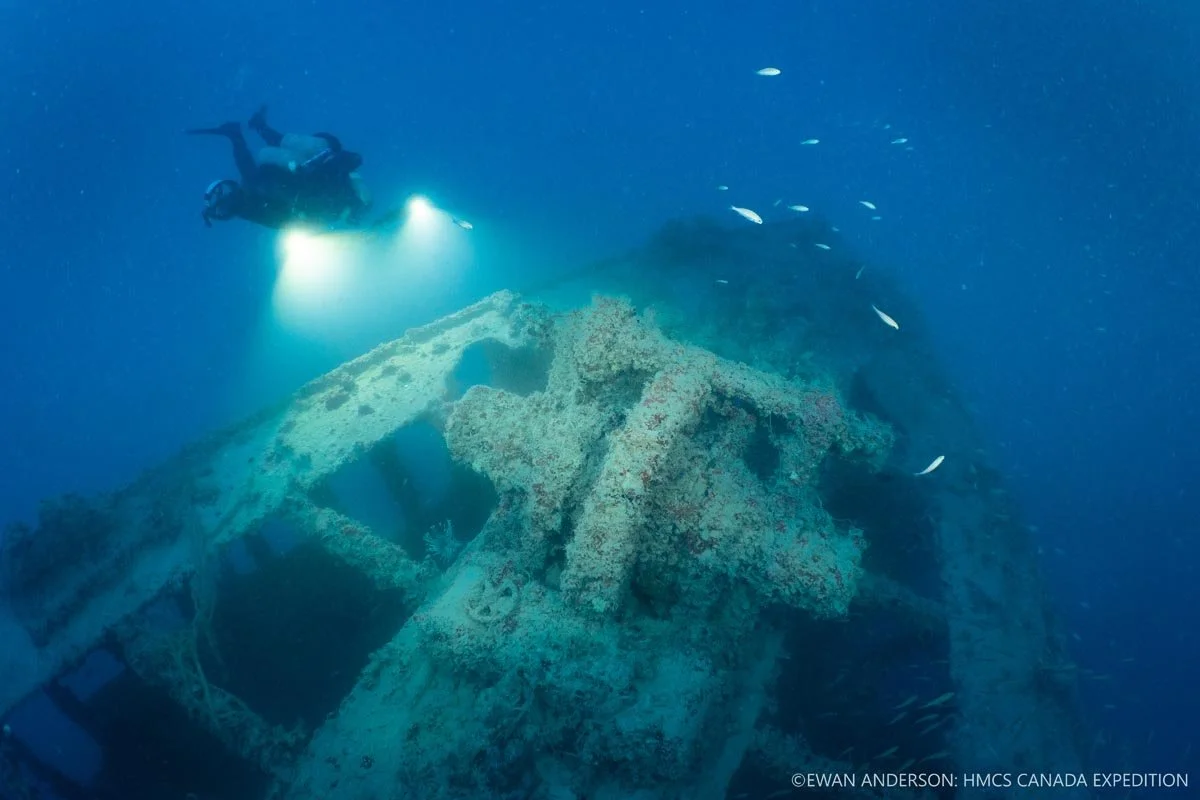
Diver Jason Cook illuminates the bow of HMCS Canada, surrounded by a school of bar jacks (Carangoides ruber).
Diver Jason Cook illuminates the bow and port-side anchor of HMCS Canada.
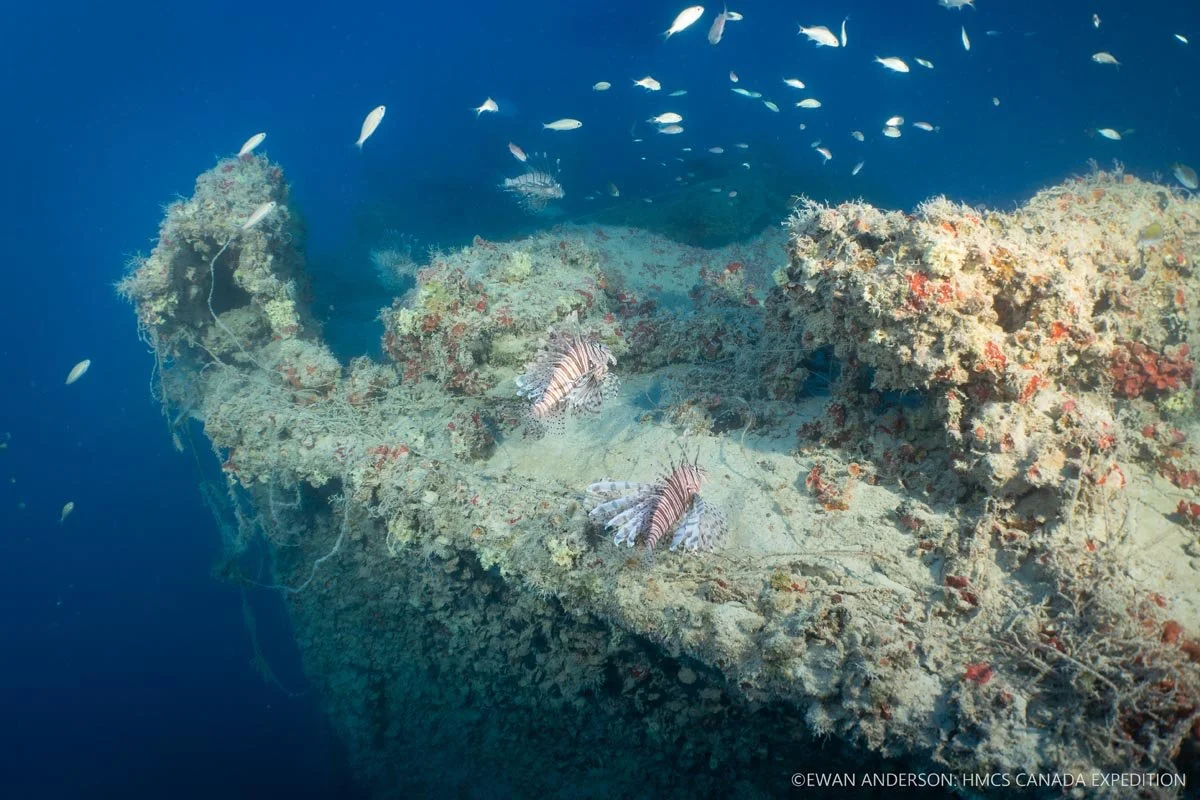
Invasive lionfish (Pterois sp.) and schooling juvenile white grunts (Haemulon plumierii) on the stern deck of HMCS Canada.
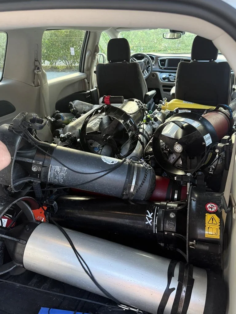
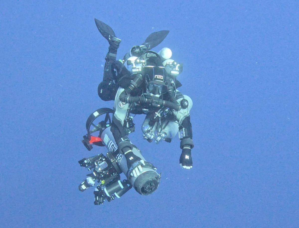
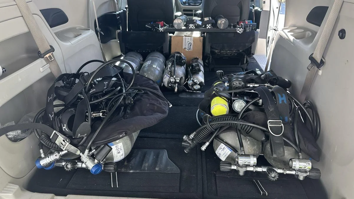
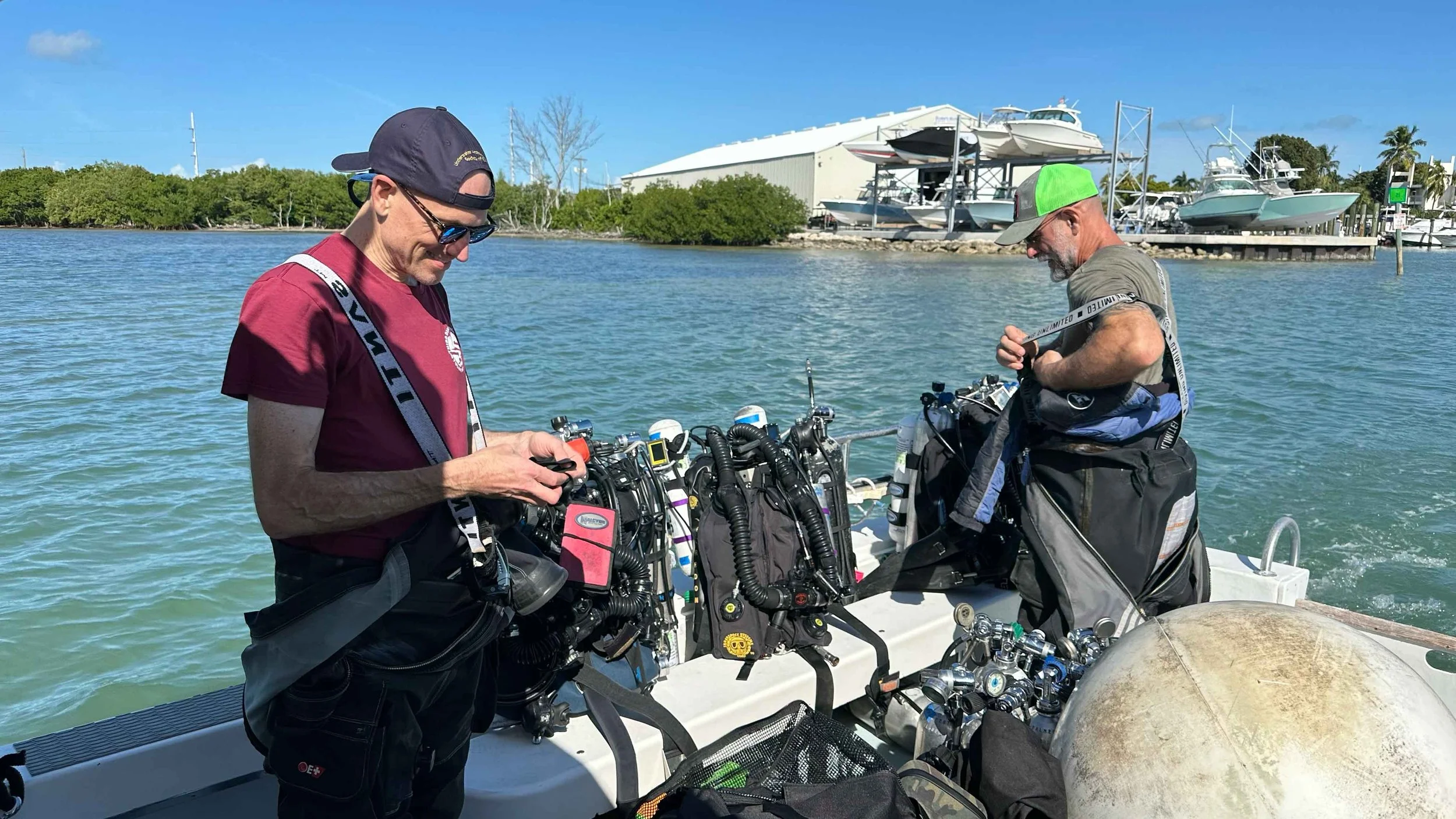
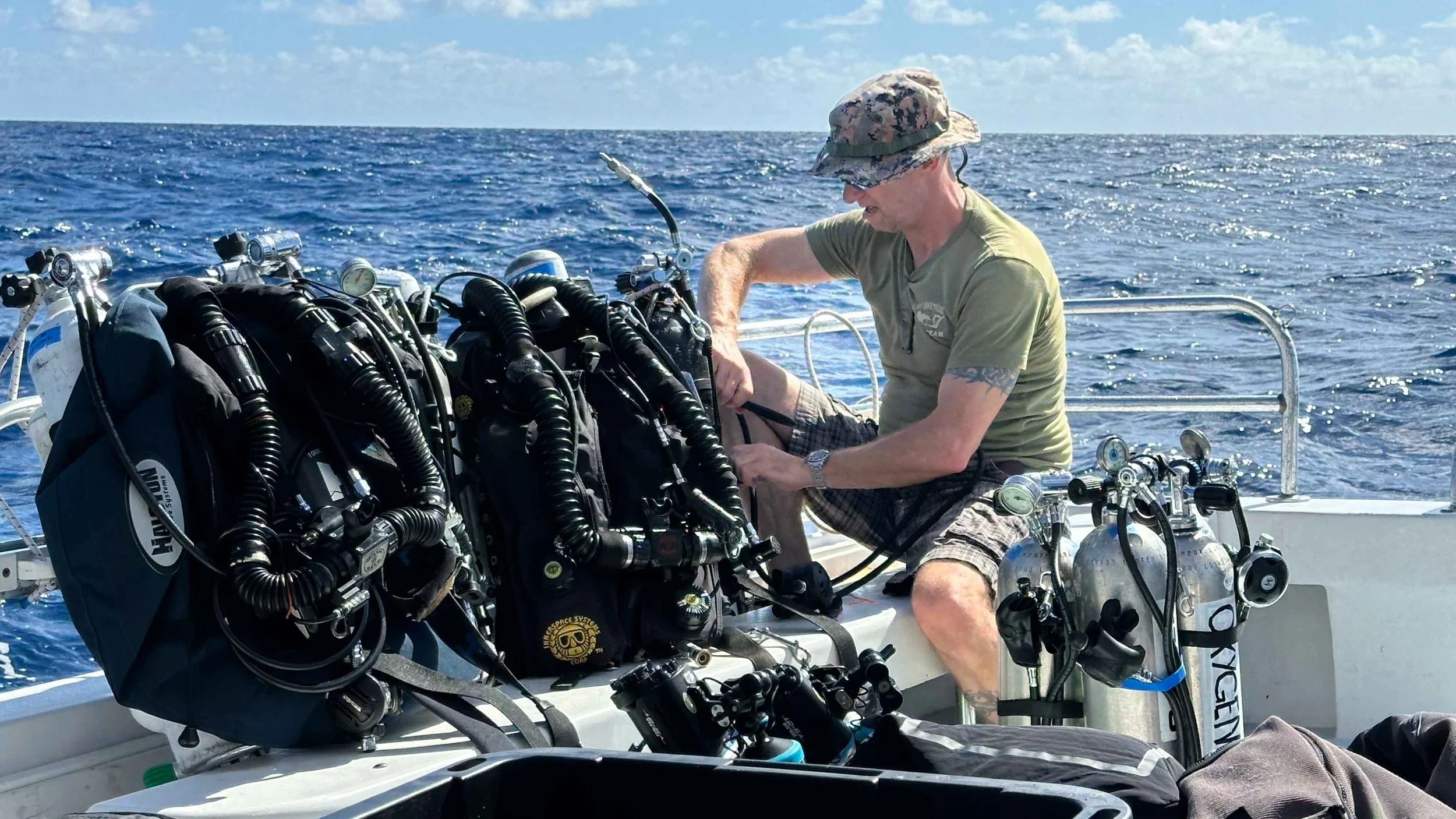
Diver Propulsion Vehicles (DPVs) and breathing-gas cylinders staged for the expedition’s technical dive team. Fully equipped, each technical diver carried approximately 300 pounds (136 kilograms) of equipment per dive.
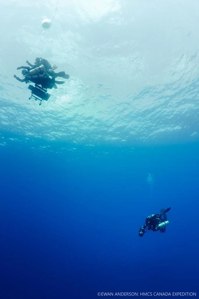
Dive teammates Roger Lacasse and Kelvin Davidson grasp the ascent line just before surfacing, while second team member Jason Cook decompresses below.
Detail view of the fishing net entanglement over the engine-room skylights of HMCS Canada.
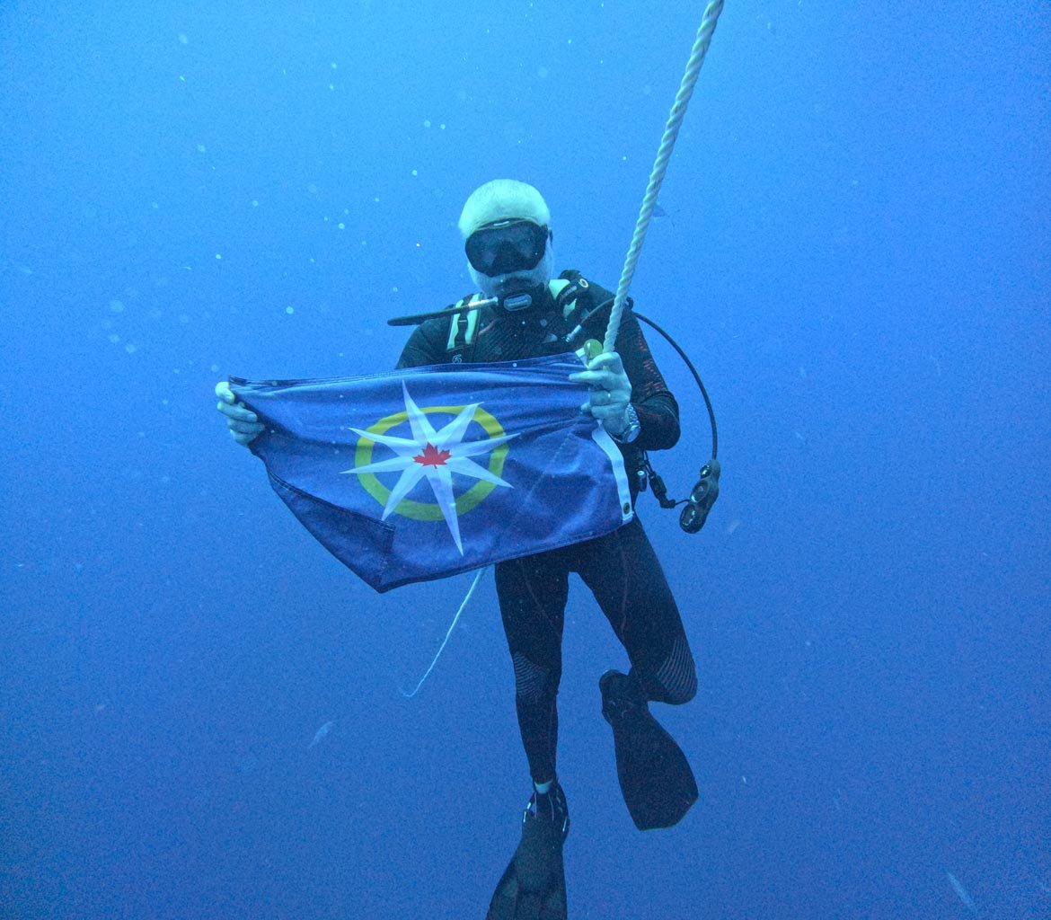
Joseph Frey with a Royal Canadian Geographical Society expedition flag above the wreck of HMCS Canada.
Diver Jason Cook illuminates a decaying fishing net draped across the engine-room skylights.
Brackets that once supported the starboard propeller shaft. Both the shaft and propeller are missing from the wreck site.
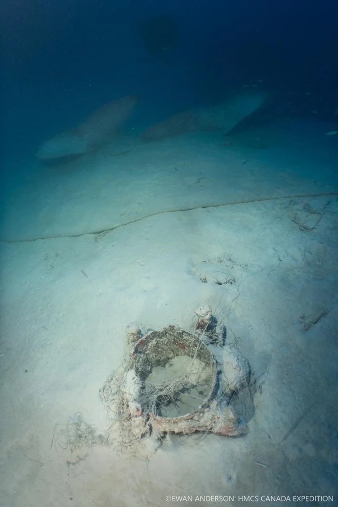
A broken deck fitting (foreground), tangled in fishing line, within the starboard-side debris field near the pair of spare propellers (background).
Ewan Anderson completing 65 minutes of decompression following a 25-minute dive on HMCS Canada.
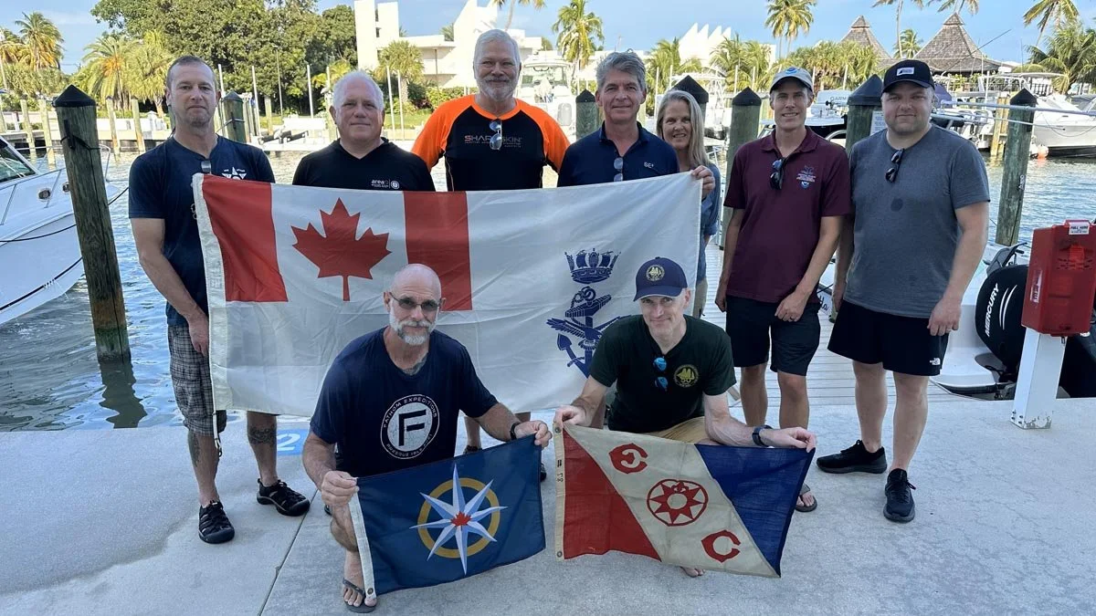
Group photograph. Front row (left to right): Kelvin Davidson (with RCGS expedition flag), Ewan Anderson (with Explorers Club expedition flag). Back row (left to right): Rob DeProy, Guy Shockey, Joseph Frey, Roger Lacasse, Brenda Altmeier (NOAA), Matthew Lawrence (NOAA), Jason Cook.
Diver Jason Cook illuminates the port-side propeller and stern of HMCS Canada at a depth of 67 m (220 feet).
Unloading one of four vans and SUVs of dive equipment on the first morning of the expedition.
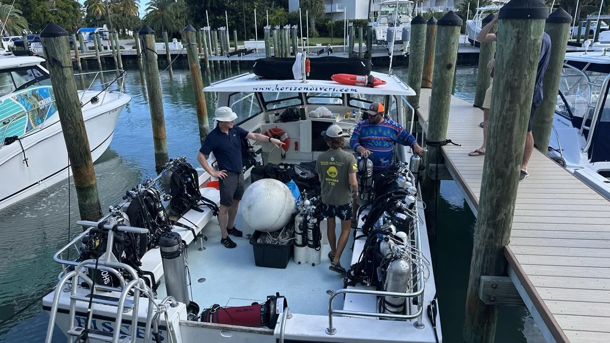
Loading the expedition dive vessel Pisces on the first morning of operations. From left to right: Roger Lacasse, 3D Photogrammetry Lead; Luke Dunn, First Mate; and Jeff Knapp, Captain. Pisces and her crew are operated by Horizon Divers, Key Largo.
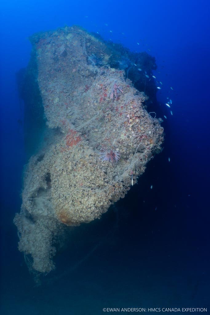
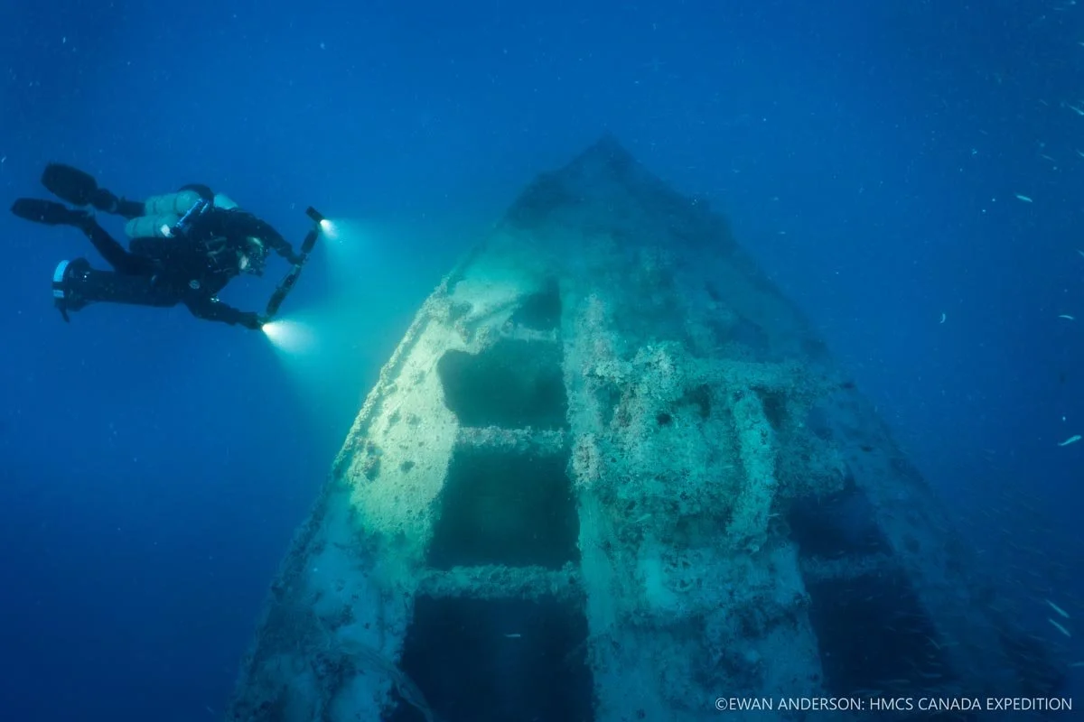
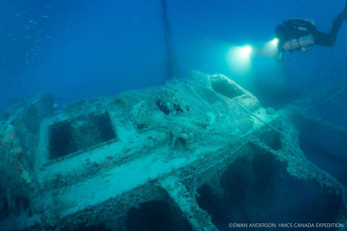
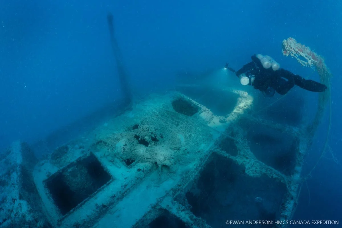
The stern of HMCS Canada, bent and twisted when the sinking ship struck the seafloor nearly 70 m (230 feet) below the surface. The structure is now heavily encrusted with marine life, draped with fishing line, and inhabited by multiple fish species.
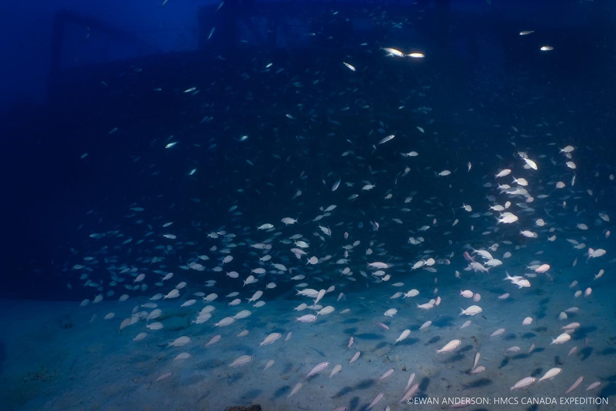
Schooling juvenile grunts and bogas (Haemulon sp.) with the wreck of HMCS Canada looming in the background.
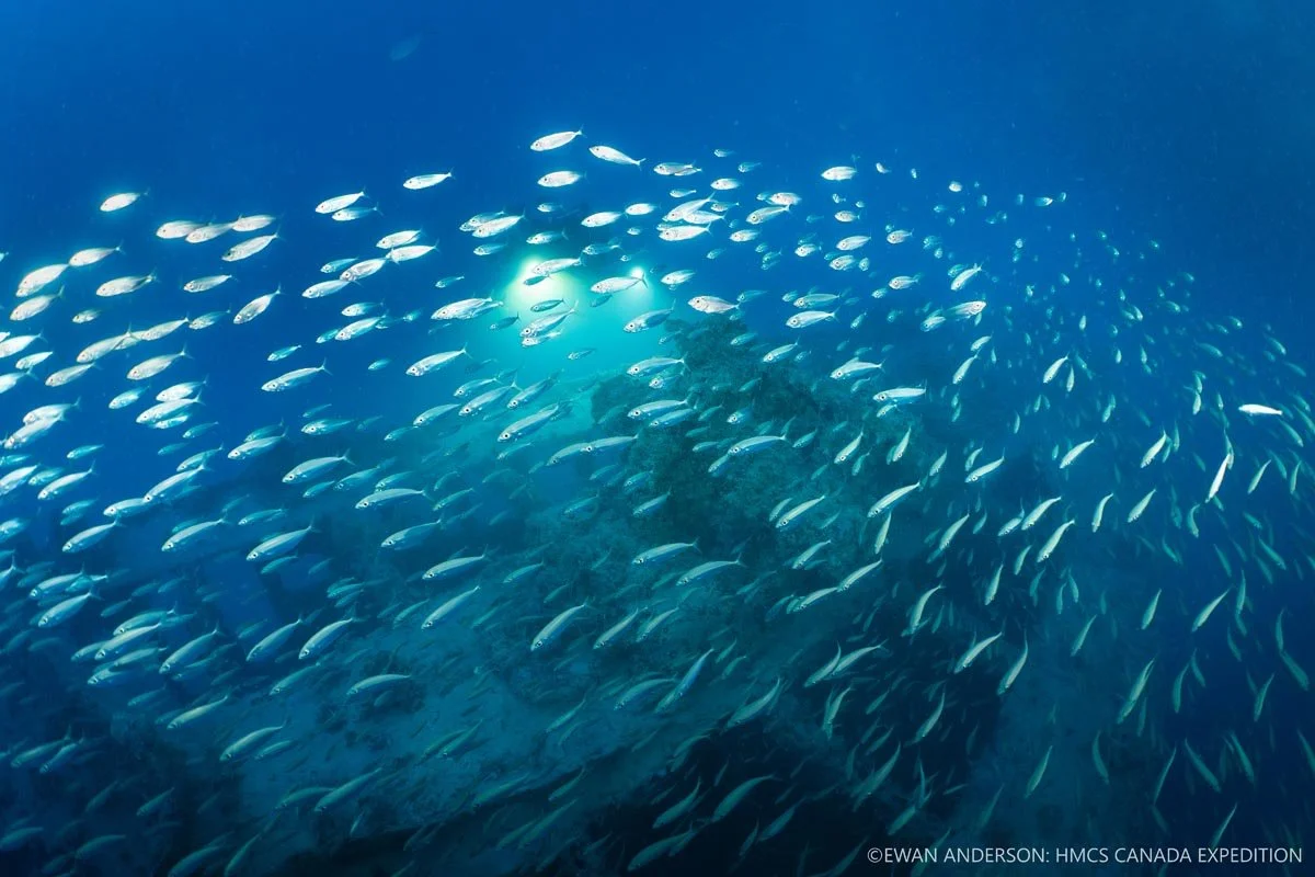
A school of scads (Decapterus sp.) swims over the anchor windlass on the foredeck as diver Jason Cook films using high-intensity underwater lighting.
Ewan Anderson (left) and Kelvin Davidson prepare for the day’s dive as Pisces departs Caloosa Cove Marina on Lower Matecumbe Key for the HMCS Canada site, 6 miles (10 kilometres) offshore.
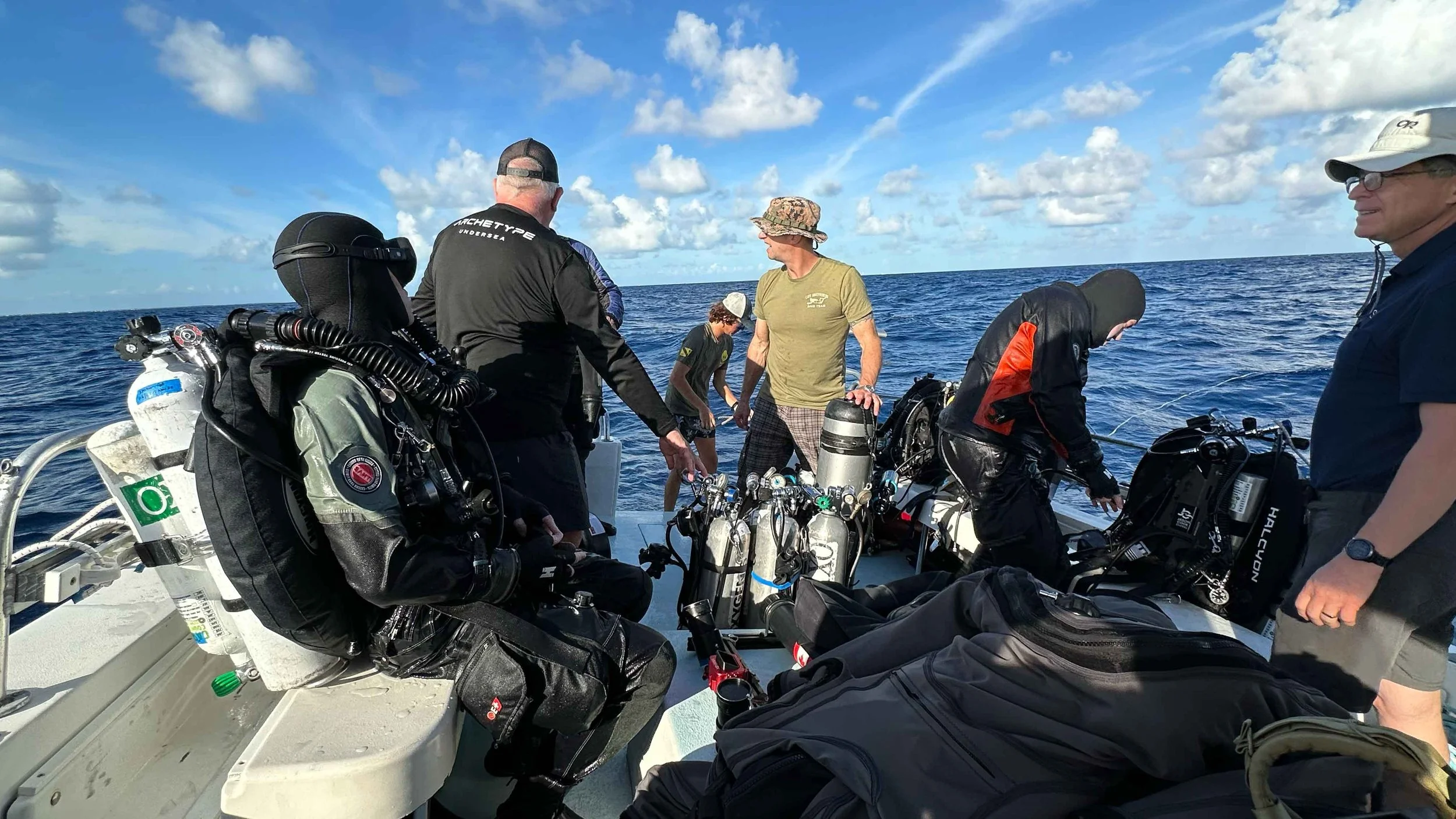
Preparing to deploy Team 2 onto the wreck of HMCS Canada. From left to right: Ewan Anderson, Guy Shockey, Luke Dunn, Rob DeProy, Jason Cook, Roger Lacasse.
Rob DeProy, retired Coxswain of the Royal Canadian Navy’s Fleet Diving Unit (Pacific), preparing his equipment for a dive on HMCS Canada.
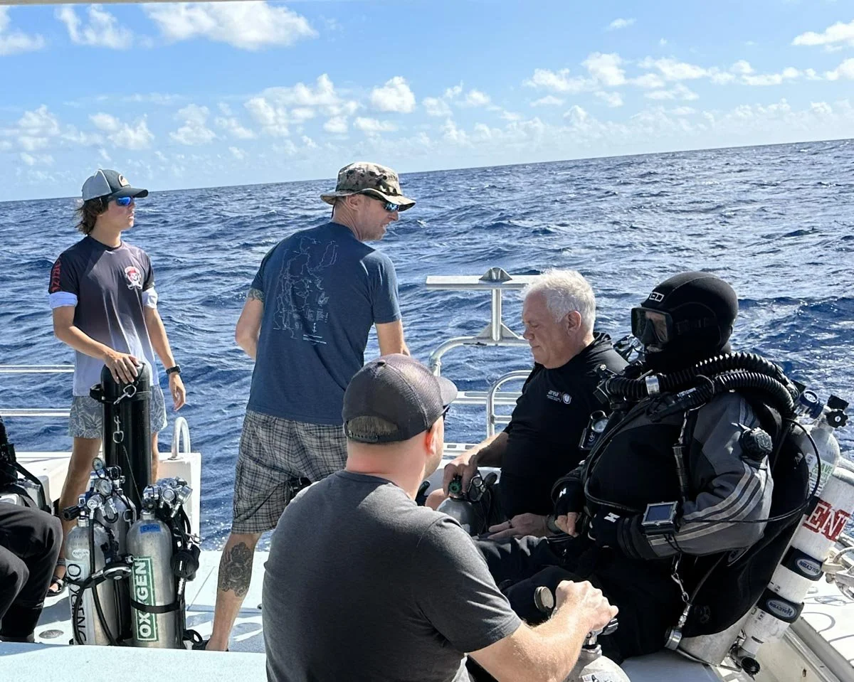
Guy Shockey and Kelvin Davidson prepare to dive. From left to right: Luke Dunn, Rob DeProy, Jason Cook, Guy Shockey, Kelvin Davidson.
Ewan Anderson (left) and Jason Cook (right) prepare to dive while being assisted by Expedition Lead Diver Guy Shockey (centre).
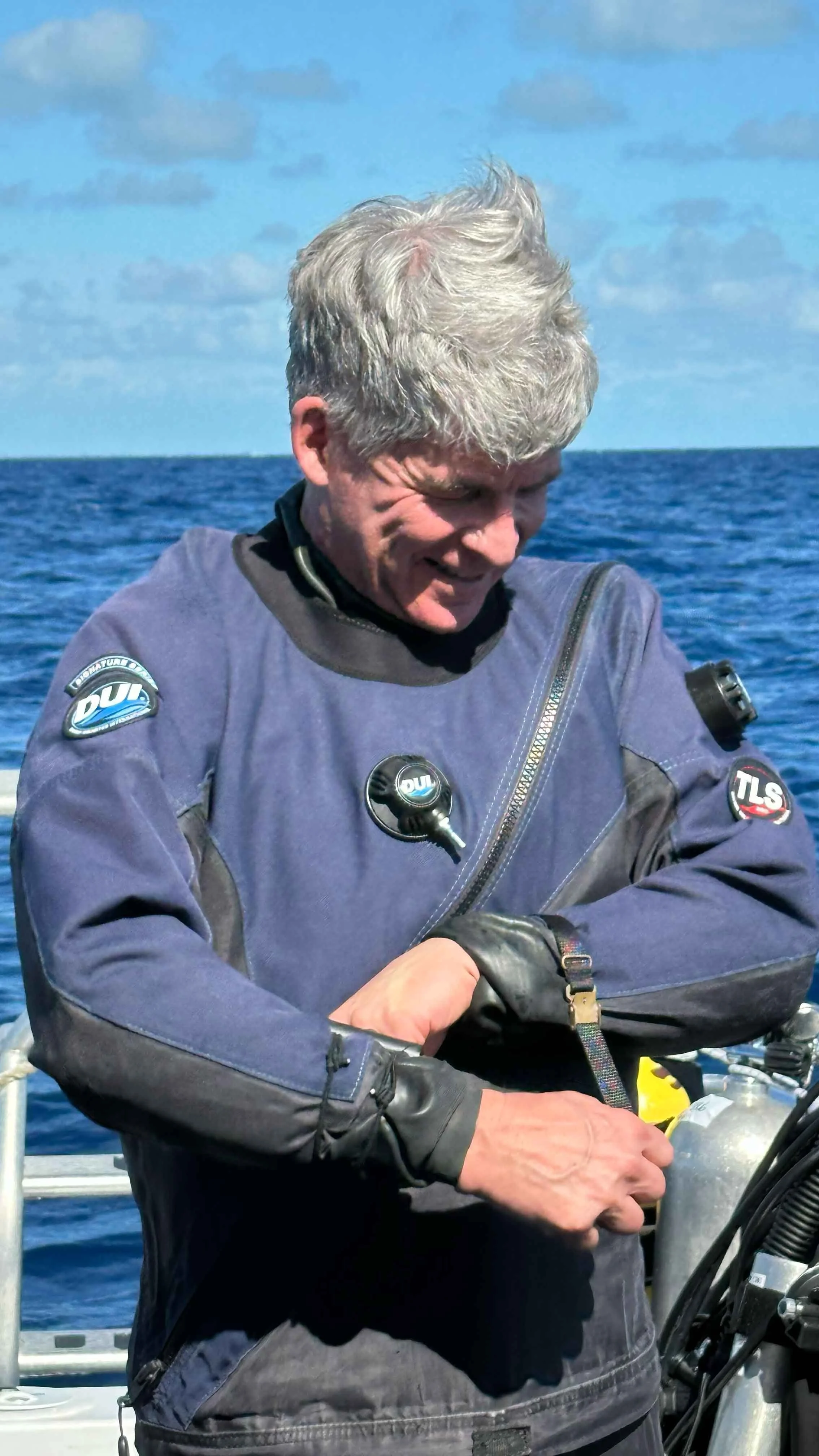
Roger Lacasse, 3D Photogrammetry Lead, suiting up for a dive on HMCS Canada.
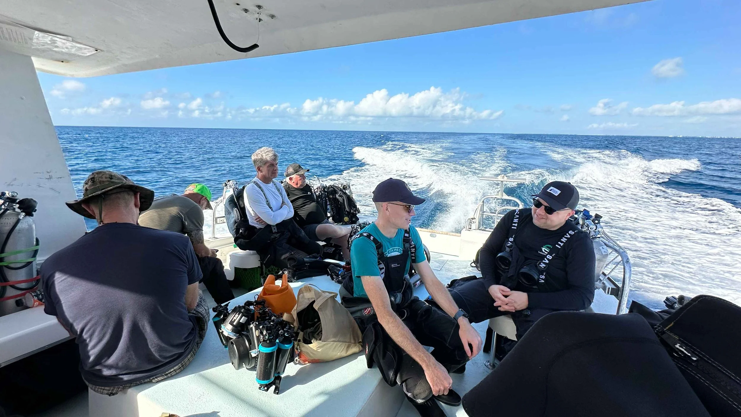
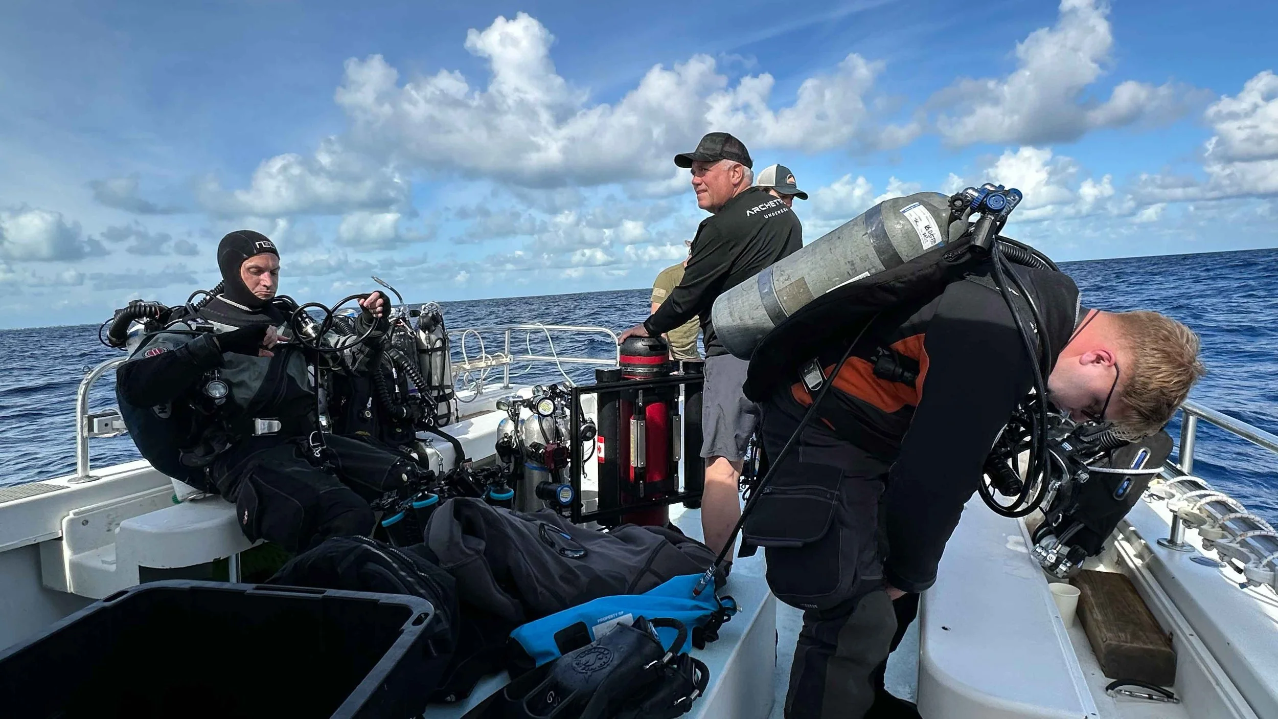
The expedition’s three two-person dive teams assembled on deck. Team 1 (left, stern): Roger Lacasse and Guy Shockey. Team 2 (centre, left to right): Ewan Anderson and Jason Cook. Team 3 (left, forward, backs turned): Rob DeProy and Kelvin Davidson.
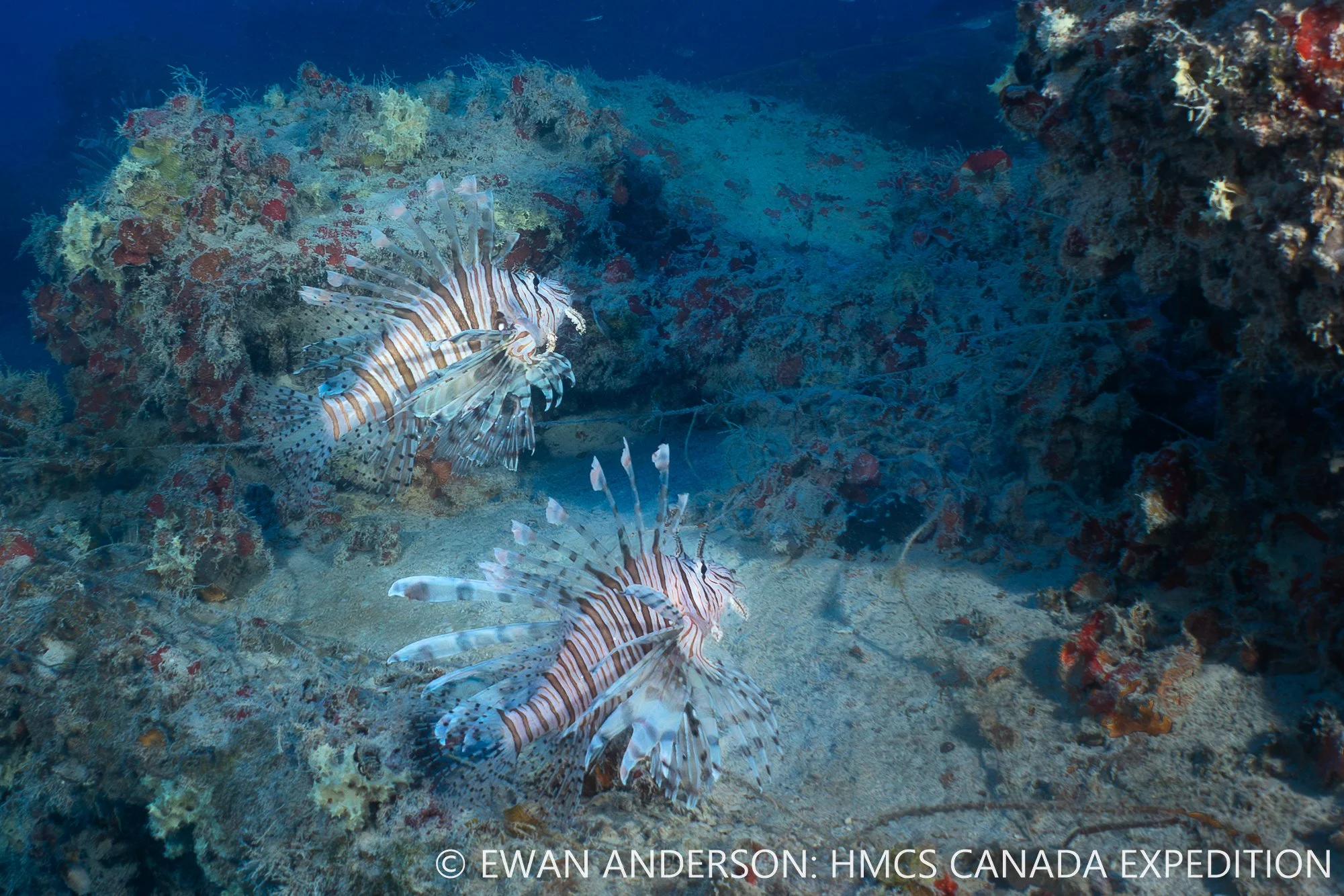
Lionfish (Pterois sp.) are well-established on the wreck of the HMCS Canada.
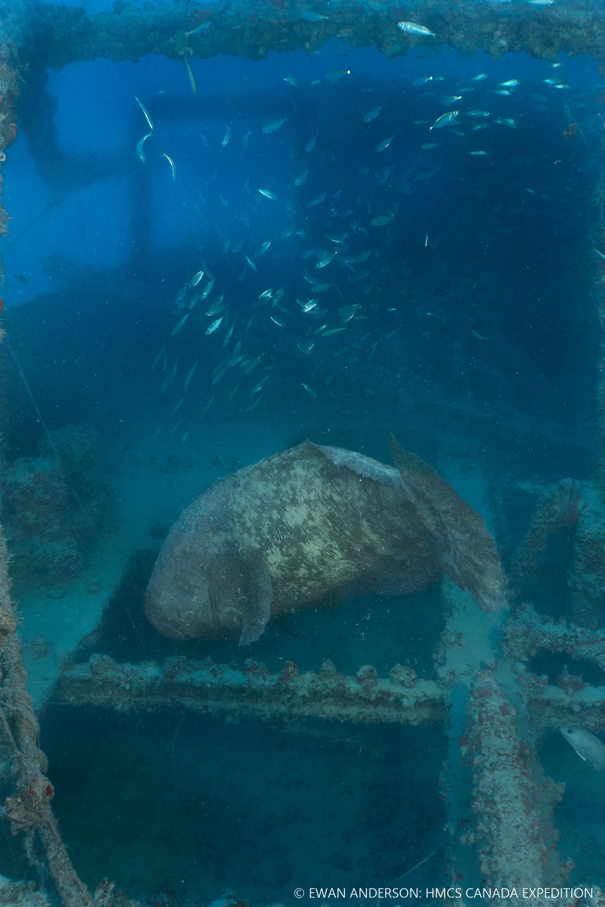
A Goliath Grouper (Epinephelus itajara) flees from expedition divers, despite its substantial size (likely over 2 m (6 feet) long and weighing more than 180 kg (400 lbs).
Expedition Videos
Video Captions
Top Row Left - 1. Photogrammetry specialist and expedition diver Roger Lacasse deploys a camera-and-lighting sled to document the bow and deck of HMCS Canada. Video credit: Ewan Anderson / HMCS Canada Expedition 2025
Top Row Middle - 2. Likely the first motion footage ever recorded of HMCS Canada in its more than century-long history. The video documents key identifying features, including the distinctive curved bow, collapsed bridge, upper hull and stern remains, and deck areas once planked in wood and now lost to marine wood-boring organisms. Invasive lionfish are visible, illustrating how this historic First World War–era warship has become part of a modern marine ecosystem. Video credit: Ewan Anderson / HMCS Canada Expedition 2025
Top Row Right - 3. The remaining port-side propeller and drive shaft of HMCS Canada. This propeller represents what the starboard propeller would have looked like prior to its complete loss, documented in the following video. Notably, two of the port propeller’s four blades have been cleanly sheared off, suggesting a high-energy failure event. Video credit: Jason Cook / HMCS Canada Expedition 2025
Middle Row Left - 4. Motion footage of the starboard side of HMCS Canada where the starboard propeller and drive shaft are entirely absent. When contrasted with the surviving port-side assembly documented in Video 39, the loss highlights a pronounced asymmetry in the wreck’s propulsion remains. The cause and timing of this damage remain undetermined. Video credit: Jason Cook / HMCS Canada Expedition 2025
Middle Row Middle - 5. Motion footage of two completely intact spare propellers resting within the debris field of HMCS Canada. These spare propellers likely slid off the deck as the ship sank and were not part of the installed propulsion system. Their pristine condition provides a clear reference for how the ship’s port and starboard propellers would have appeared when originally fitted. Video credit: Jason Cook / HMCS Canada Expedition 2025
Middle Row Right - 6. A 2½-minute sequence documenting expedition divers Guy Shockey and Rob DeProy preparing to enter the water with full technical diving equipment, including Diver Propulsion Vehicles (DPVs), a camera sled, and multiple breathing-gas cylinders. The footage follows the divers from final checks through water entry and submergence, illustrating the logistical complexity of deploying technical divers for deep wreck documentation. Video credit: Joseph Frey / HMCS Canada Expedition 2025
Bottom Row Left - 7. This sequence documents the controlled deployment of our photogrammetry specialist Roger Lacasse from the stern of Pisces under pitching sea conditions encountered on three of the four operational days. The footage highlights the risks associated with launching a fully equipped technical diver—carrying approximately 136 kilograms (300 pounds) of equipment—while the vessel is in motion. Effective crew coordination, timing, and physical support are critical to reducing the risk of knee and lower-limb injuries during entry. Video credit: Joseph Frey / HMCS Canada Expedition 2025
Development of the 3D Photogrammetry Model
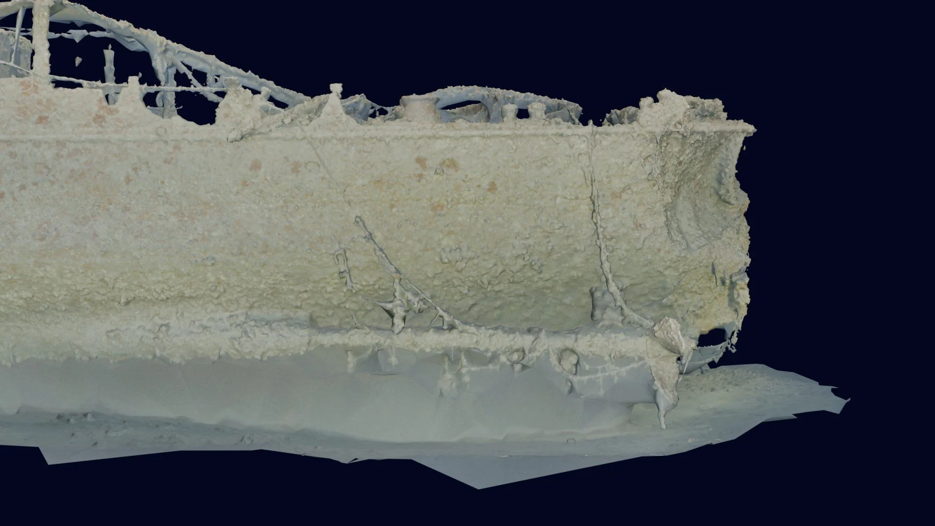
Close-up of the photogrammetry model highlighting hull fracture features on the port side of HMCS Canada.
HMCS Canada photogrammetry model viewed from the port bow. The anchor and the vessel’s distinctive bow form are visible in the foreground.
HMCS Canada photogrammetry model viewed from the starboard side.
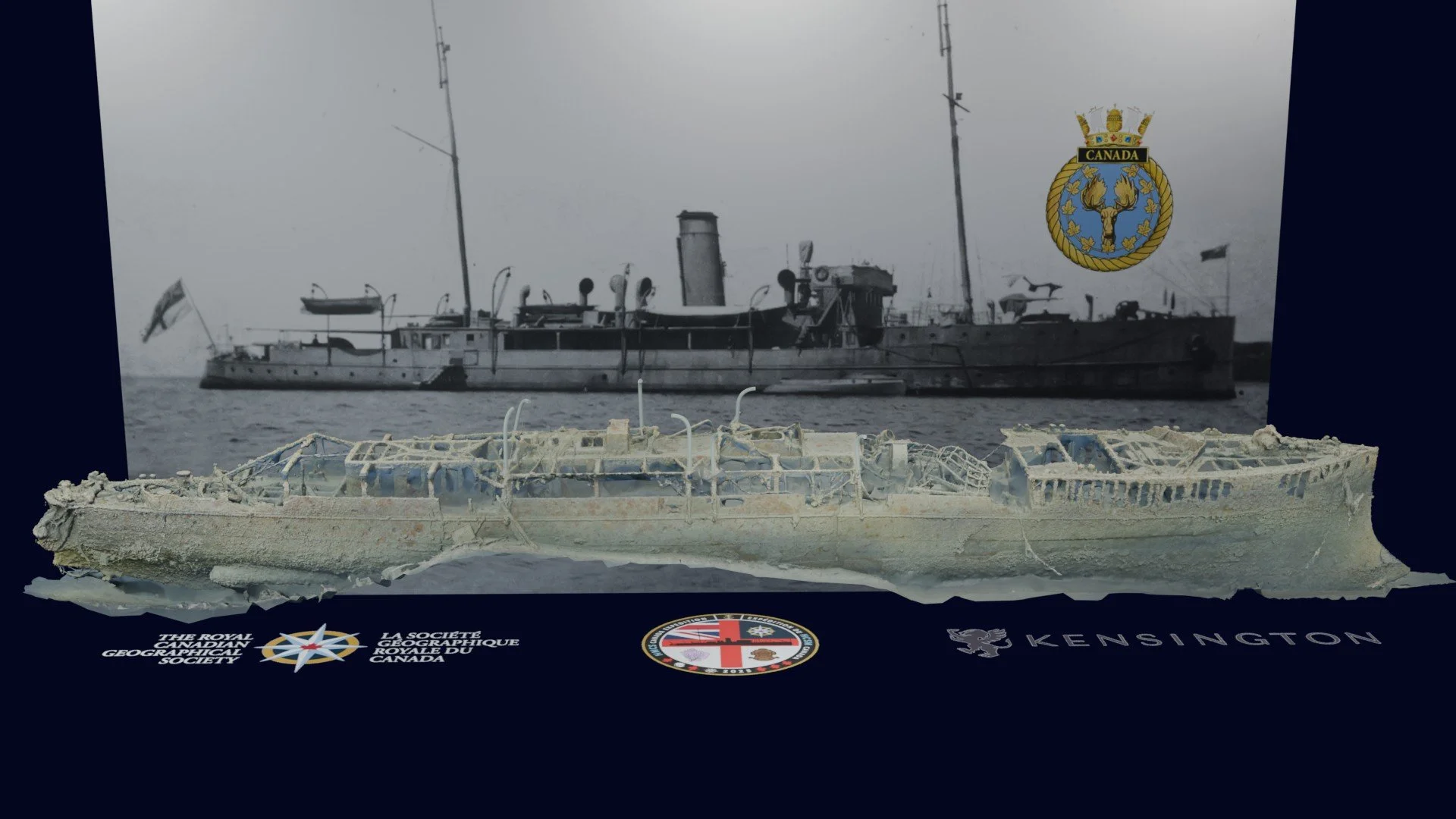
HMCS Canada photogrammetry model viewed from the starboard side, with expedition insignia in the foreground and a historical photograph of HMCS Canada (summer 1918) in the background.
HMCS Canada photogrammetry model viewed from the starboard bow. The anchor and the vessel’s distinctive bow shape are visible in the foreground.
HMCS Canada photogrammetry model viewed from the starboard bow, with expedition insignia in the foreground and a historical photograph of HMCS Canada (summer 1918) in the background.
HMCS Canada photogrammetry model viewed from the starboard stern.
HMCS Canada photogrammetry model viewed from the starboard stern, with expedition insignia in the foreground and a historical photograph of HMCS Canada (summer 1918) in the background.
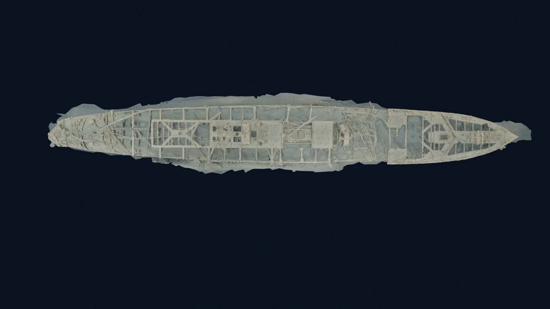
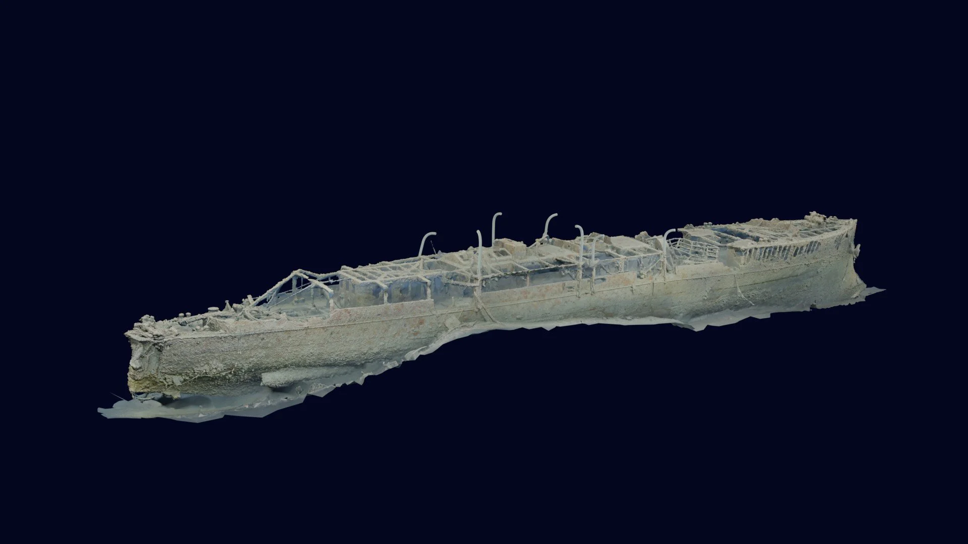
HMCS Canada photogrammetry model viewed from directly above, revealing internal framing and collapsed deck structures.
HMCS Canada photogrammetry model viewed from directly above with expedition insignia.
Aft portion of the HMCS Canada photogrammetry model showing evidence of significant sediment scouring by prevailing currents.
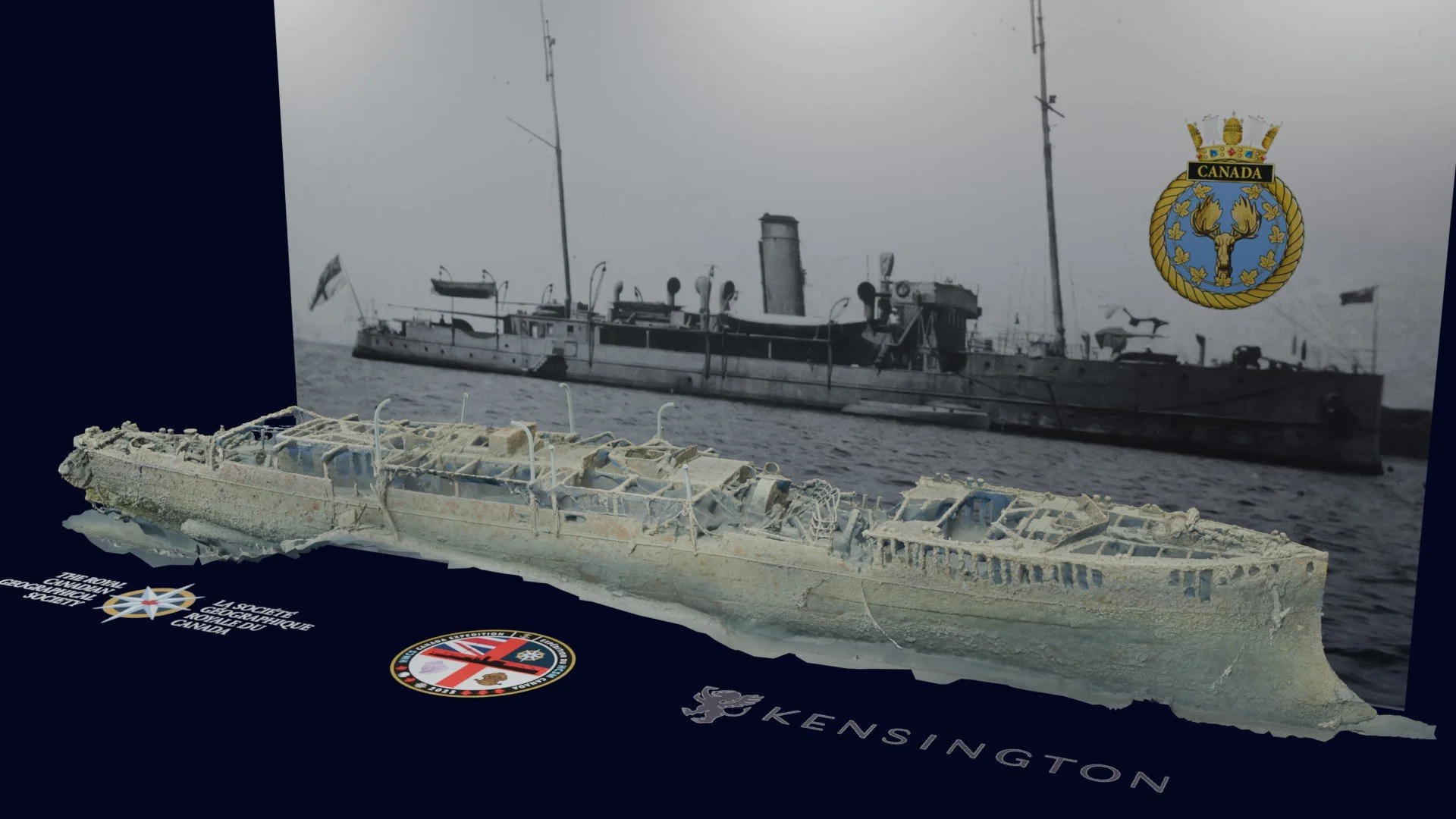
HMCS Canada photogrammetry model viewed from the starboard bow, with expedition insignia in the foreground and a historical photograph of HMCS Canada (summer 1918) in the background.
HMCS Canada photogrammetry model viewed from directly above with expedition insignia.
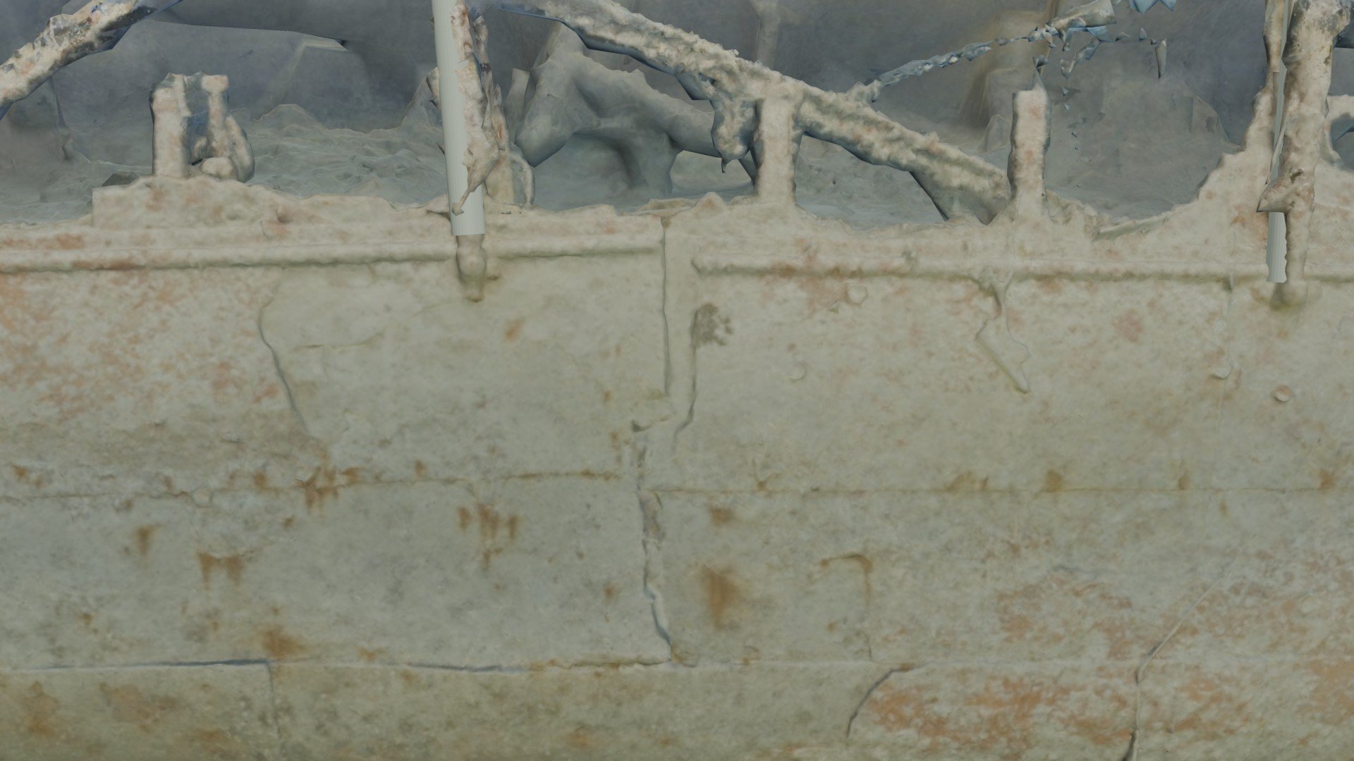
Close-up of the photogrammetry model highlighting hull fracture features on the starboard side of HMCS Canada.
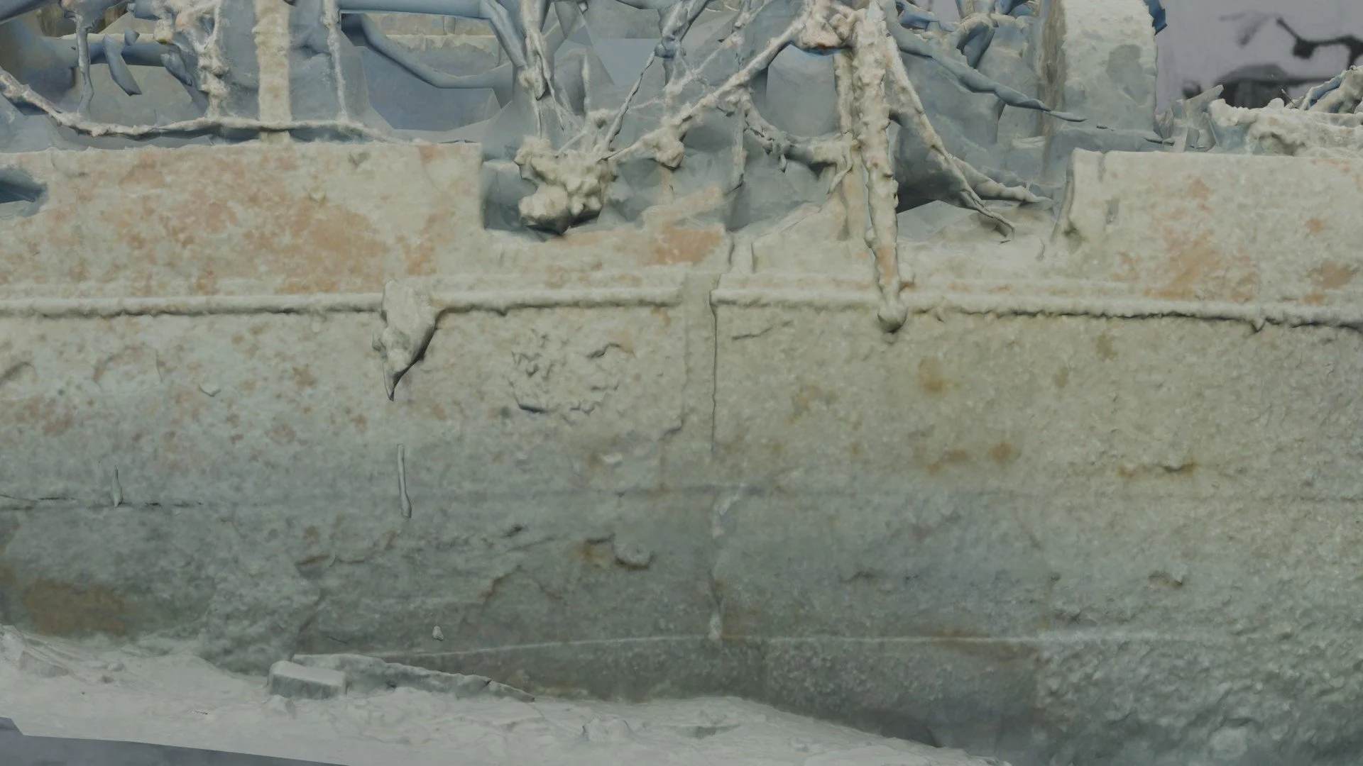
Close-up of the photogrammetry model highlighting hull fracture features on the port side of HMCS Canada.
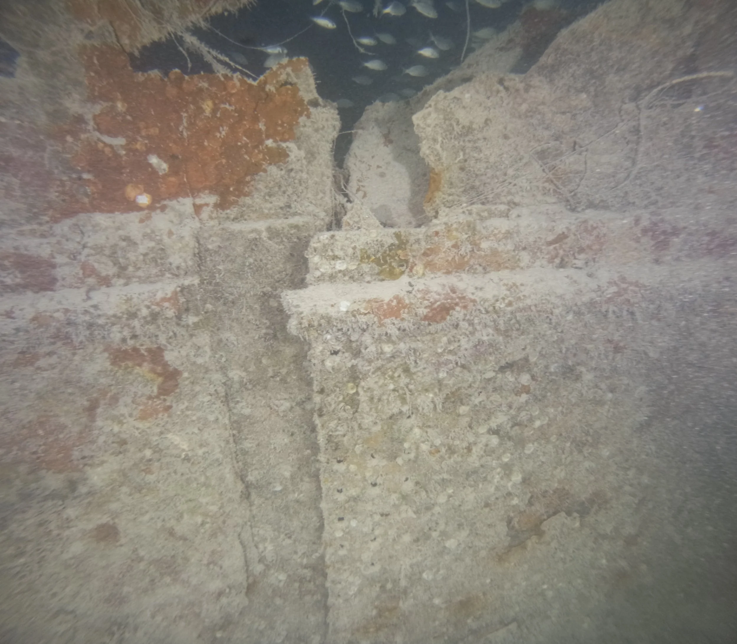
Underwater photograph confirming hull fracture features documented in the photogrammetry model on the starboard side of HMCS Canada.
HMCS Canada Expedition Archaeological and Structural Assessment
HMCS Canada Expedition Invasives and Ecological Impacts
Integrated Marine Archaeology and Marine Sciences Analysis (Completed)
As part of the HMCS Canada Expedition’s interdisciplinary mandate, a comprehensive integrated analysis of the wreck site is currently being conducted by the National Oceanic and Atmospheric Administration (NOAA). This work combines marine archaeological assessment with marine sciences analysis, drawing on more than 10,600 high-resolution underwater photographs collected during the expedition and provided to NOAA for post-expedition study.
The forthcoming analysis will address both the cultural and ecological dimensions of the site, including:
-
Assessment of the ship’s surviving structure, damage patterns, and long-term stability, including the effects of currents, sediment movement, and biological activity.
-
New findings related to the vessel’s construction and modifications across its service life, from its 1904 construction, 1912 naval upgrading, wartime up-arming between 1915–1916, and 1924 conversion to a luxury passenger liner, through to its final voyage and sinking.
-
Documentation of species distribution, abundance, and habitat use across the wreck, examining the role of HMCS Canada as an artificial reef within the surrounding marine environment.
-
Analysis of the effects of fishing activity, anchoring, and other human interactions, alongside natural environmental processes shaping the wreck site over time.
-
Evidence-based recommendations to support the long-term protection, documentation, and management of the wreck as both a historic site and a functioning marine habitat.
Upon receipt, NOAA’s completed scientific report and associated findings will be presented in this section. Together, these results will complement the expedition’s historical research, archaeological documentation, and completed 3D photogrammetry model, reinforcing the project’s integrated approach to maritime heritage, marine science, and public education.

Media Coverage and Speaking Engagements
This section brings together published commentary, authored features, and forthcoming media coverage related to the HMCS Canada Expedition. As a historically focused, research-driven project, public engagement has emphasized authoritative interpretation and long-form storytelling rather than real-time media updates.
Media coverage:
“Honouring the Royal Canadian Navy’s Legacy at 70 Metres.”
Member’s News, Royal Canadian Military Institute, September–October 2025.
An interpretive feature authored by expedition lead Joseph Frey, situating the expedition within the Royal Canadian Navy’s early history and commemorative traditions.
HMCS Canada From Warship to Reef, feature article in Alert Diver (June 2026), documenting the expedition’s technical diving operations, photogrammetry methodology, and historical significance by Joseph Frey. https://dan.org/alert-diver/article/from-warship-to-reef/
CBC News Network (July 2, 2026) CBC News Network senior reporter Brett Ruskin interviewed expedition leader Joseph Frey for a 3½-minute nationally broadcast feature marking the 100th anniversary of the sinking of HMCS Canada. The segment explored the remarkable history of Canada's first purpose-built armed government vessel, from her service as the Royal Canadian Navy's second flagship and survival of the Halifax Explosion to her final voyage and sinking in the Florida Keys on 2 July 1926. The feature also highlighted the achievements of the HMCS Canada Expedition 2025, including the first comprehensive 3D photogrammetric survey of the wreck undertaken in partnership with the Florida Keys National Marine Sanctuary. The interview was broadcast nationally on CBC News Network's morning programming and helped introduce the expedition and its scientific, archaeological, ecological, and historical significance to a Canada-wide audience. https://www.youtube.com/watch?v=Jhy2xn8LrW8
Explore: A Canadian Geographic Podcast (July 14, 2026) Expedition lead Joseph Frey was interviewed by journalist, broadcaster, and explorer David McGuffin for Explore: A Canadian Geographic Podcast. The discussion examined the history of HMCS Canada, Canada's first purpose-built armed government vessel, and the results of the HMCS Canada Expedition 2025, which completed the first comprehensive 3D photogrammetric survey of the wreck in the Florida Keys National Marine Sanctuary (FKNMS).
The interview explored the vessel's evolution from government patrol ship to the Royal Canadian Navy’s second flagship and survivor of the Halifax Explosion, as well as the challenges of documenting a historic wreck site at a depth of 70 metres (235 feet). Topics included underwater photogrammetry, expedition planning and execution, and the role of exploration in preserving and interpreting Canada's maritime heritage for future generations, along with the expedition’s contribution to the marine archaeology and ecology of the FKNMS.
Hosted by David McGuffin, Fellow of The Royal Canadian Geographical Society and host of Explore: A Canadian Geographic Podcast. https://canadiangeographic.ca/podcasts/hmcs-canada-the-forgotten-ship-that-built-a-navy-with-joseph-frey/ Instagram https://www.instagram.com/p/Dayd4ygpO8u/
Canadian Geographic (Autumn 2026) a feature article examining the HMCS Canada Expedition within the broader story of Royal Canadian Navy history, Canada-US-Bahamas maritime heritage, modern expedition operations, underwater archaeology, and the archaeological and marine ecological findings documented at the wreck site.
Speaking engagements:
Underwater Archaeological Society of British Columbia, Victoria, March 28, 2026, Guy Shockey
University of Toronto, Hart House, September 14, 2026, Joseph Frey
Royal Canadian Military Institute, Toronto, September 16, 2026, Joseph Frey
As additional articles, interviews, and interpretive pieces are published, they will be added to this section to provide a consolidated public record of how the HMCS Canada Expedition has been received, interpreted, and contextualized by professional, academic, and public audiences.
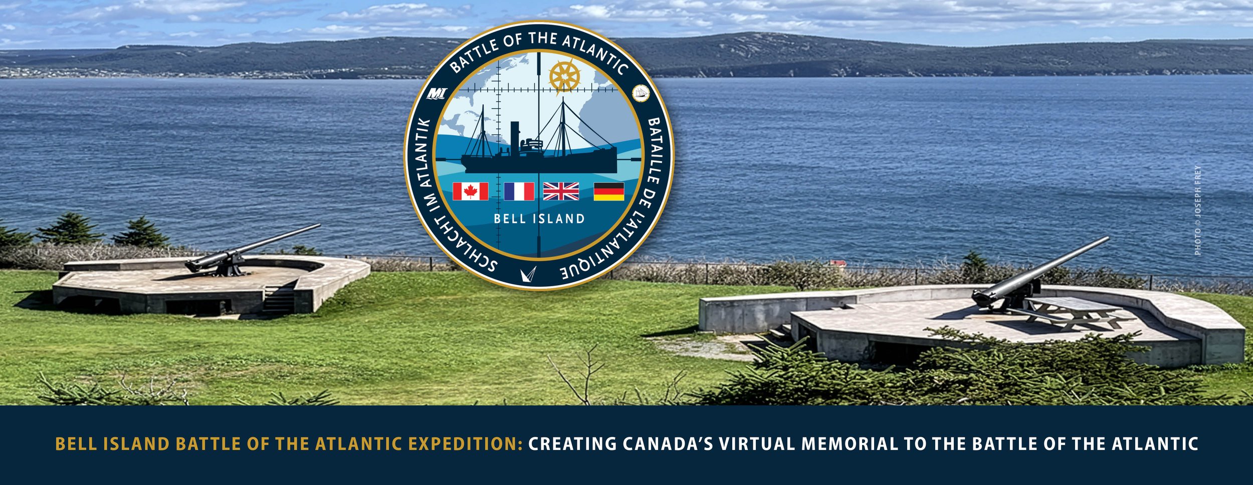
Our Next Expedition: Bell Island 2027, Newfoundland, Canada
Bell Island Battle of the Atlantic Virtual Memorial Expedition
https://battleoftheatlanticmemorial.org/
Overview
The Bell Island Battle of the Atlantic Virtual Memorial Expedition is a multidisciplinary field project designed to document, interpret, and commemorate Canada’s most intact and historically significant Second World War naval battlefield. The expedition responds to a fundamental challenge in naval history and commemoration: the absence of traditional battlefields and large cemeteries for the tens of thousands of naval and merchant sailors from all nations who died at sea during the Battle of the Atlantic, the longest campaign of the Second World War.
Unlike land warfare, naval combat leaves few visible traces. Ships sink, crews are lost offshore, and families are often left without graves to visit or landscapes that convey the scale and human cost of the conflict. As a result, much of the Battle of the Atlantic remains physically invisible despite its central importance to Canada’s wartime history and national identity.
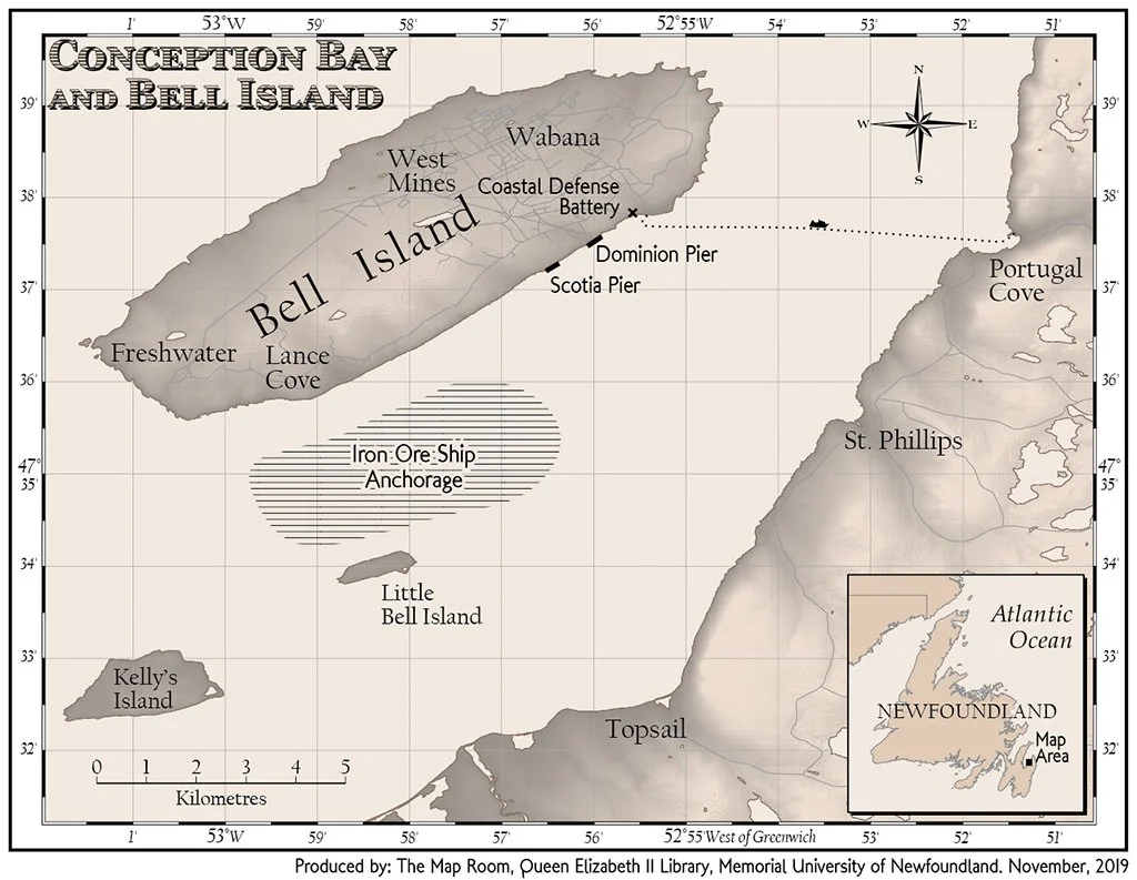
Bell Island, Newfoundland and Labrador, is one of the rare locations where the naval battlefield, the industrial target, coastal defences, and commemorative landscapes remain geographically and historically linked. In 1942, four loaded iron ore carriers were torpedoed while at anchor off Bell Island during two separate German submarine attacks. These were deliberate penetrations of a sheltered anchorage adjacent to a defended harbour and a critical wartime industrial target, rather than open-ocean interceptions. The wrecks and surviving shore features together form one of the most concentrated and interpretable Battle of the Atlantic landscapes on the Atlantic coasts of Canada and the United States.
In addition to its commemorative purpose, the expedition advances a broad range of scientific, educational, and community-focused objectives. High-resolution underwater archaeology will document the wrecks and associated industrial infrastructure as a connected cultural landscape, while marine biology and marine ecology research will establish baseline data on the wrecks as artificial reef systems within Conception Bay. The project is designed to support public education through digital visualization, academic research, and curriculum-aligned resources, while also contributing to sustainable heritage tourism by making an otherwise inaccessible naval battlefield understandable and meaningful to visitors. Together, these integrated approaches ensure that the Bell Island expedition functions not only as a memorial, but also as a living platform for science, education, and regional cultural and economic engagement.
Bell Island Attacks: Dates, Ships, and Operational Context
The Bell Island attacks occurred in two phases during the autumn of 1942 and were conducted by German submarines operating independently in western North Atlantic waters.
First attack – 5 September 1942
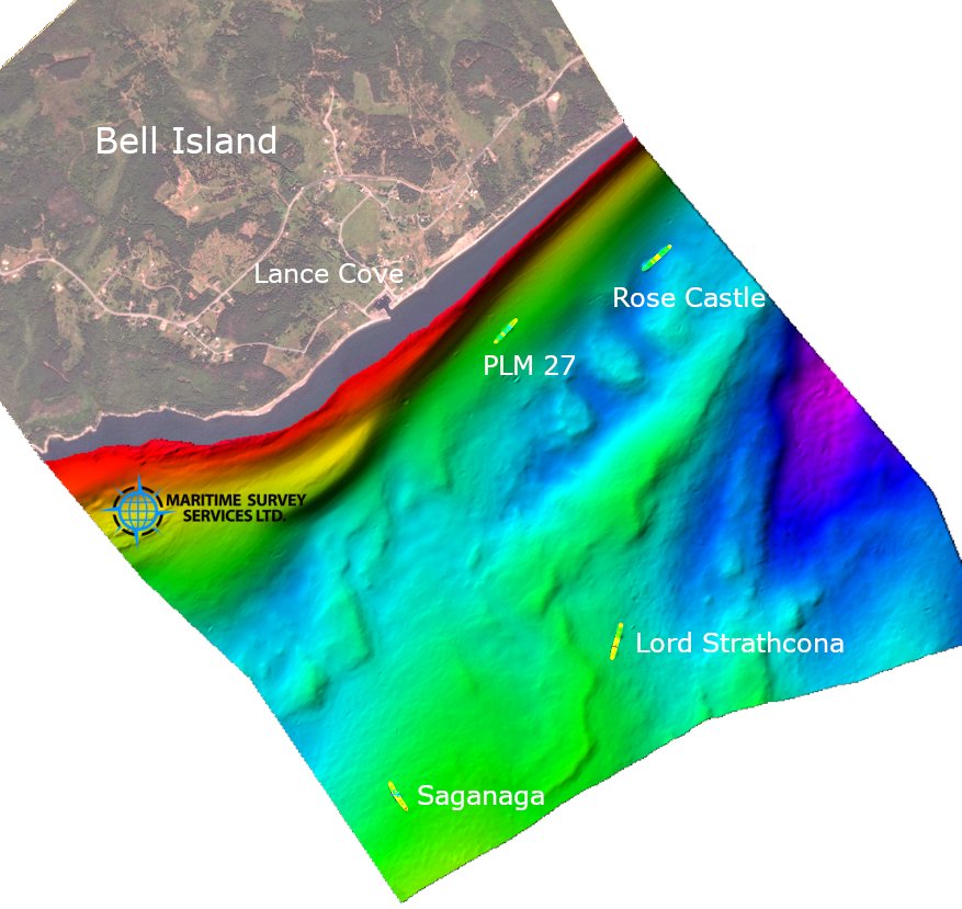
Submarine U-513 (Type IXC) entered Conception Bay and torpedoed two iron ore carriers lying at anchor:
S.S. Saganaga (British)
S.S. Lord Strathcona (Canadian)
Second attack – 2 November 1942
Submarine U-518 (Type IXC) returned to the Bell Island anchorage and torpedoed two additional iron ore carriers:
S.S. Rose Castle (Canadian)
S.S. PLM-27 (British-registered; operating under Free French control)
The second attack was also associated with damage in the Scotia Pier area.
While many vessels were sunk near shore during the intense submarine campaign of 1942, Bell Island is distinguished by the successful penetration of a sheltered anchorage and the sinking of multiple vessels in close proximity to an active industrial facility and defended harbour.
A Unique Wartime Landscape
Bell Island preserves an unusual concentration of Battle of the Atlantic features within a single geographic setting:
Four merchant shipwrecks resting offshore in Conception Bay
The remains of Scotia Pier, directly linked to wartime industrial activity and the 1942 attacks
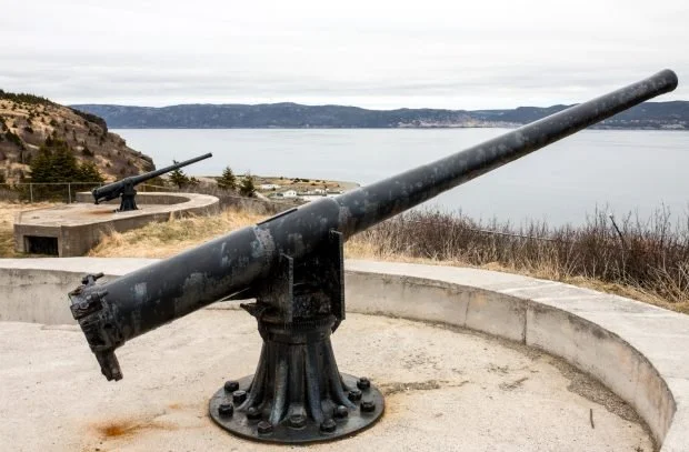
A preserved coastal artillery battery, constructed prior to and operational during 1942
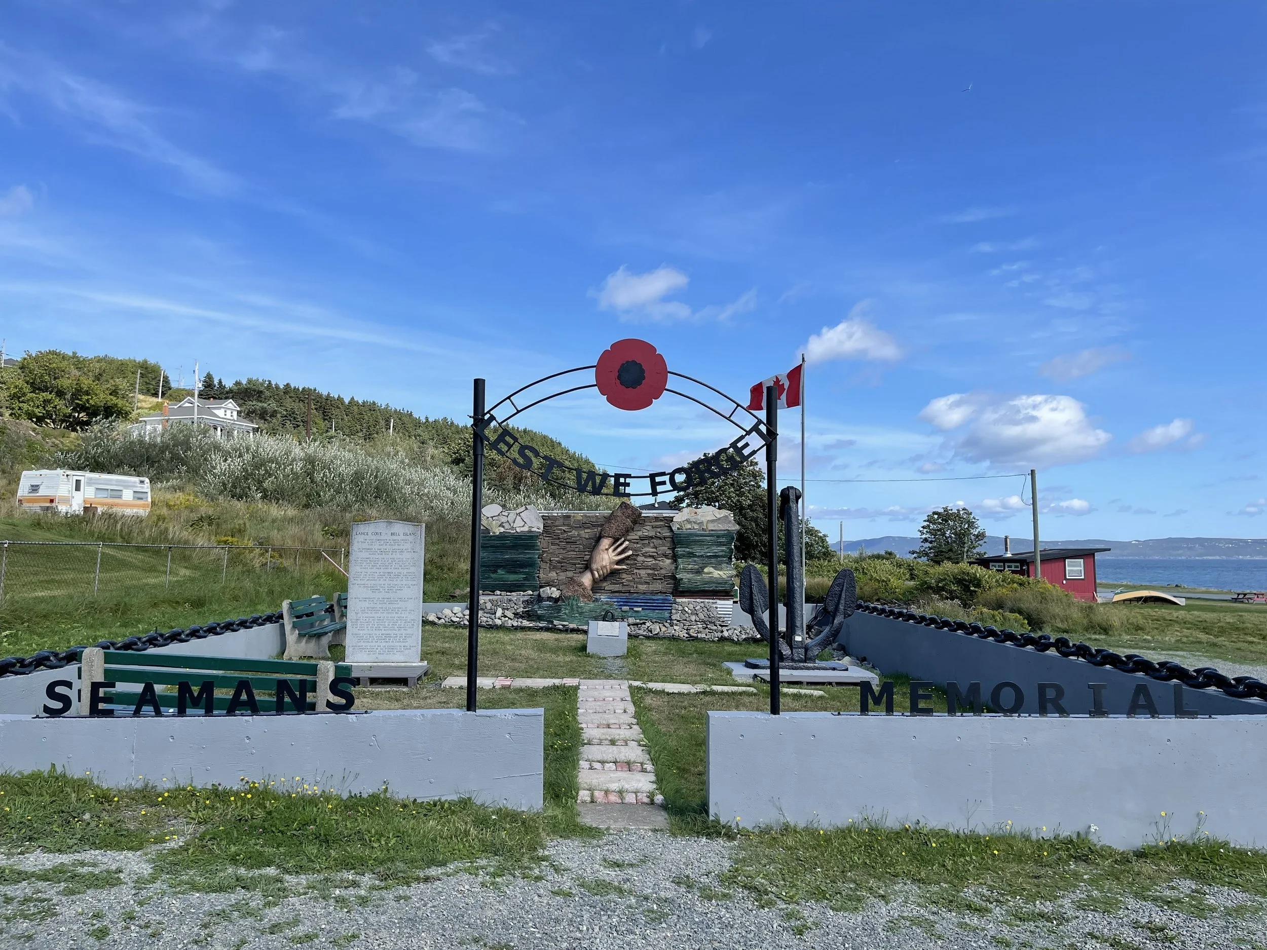
Two cemeteries associated with the events, including the Seamen’s Cemetery at Lance Cove
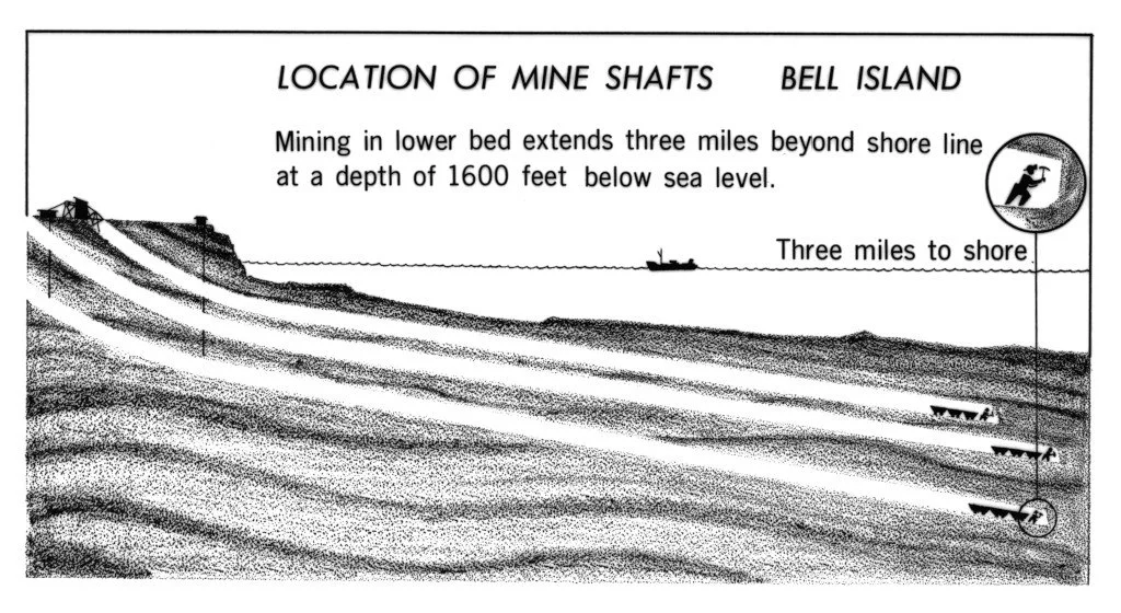
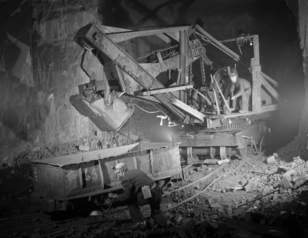
Flooded iron ore mine workings that formed the industrial heart of the wartime target
Together, these elements allow the Battle of the Atlantic to be understood not as isolated ship losses, but as a connected system linking naval operations, industrial production, coastal defence, and commemoration.
Bell Island within the North Atlantic Theatre
Within the Allied system of global theatres of war, the Battle of the Atlantic formed a distinct and continuous theatre of operations. The Canadian Northwest Atlantic Theatre was the only Allied theatre of war commanded by a Canadian, it was under the leadership of Rear Admiral—later Vice-Admiral—Leonard W. Murray, Commander-in-Chief, Canadian Northwest Atlantic.
Bell Island must also be understood within a wider North Atlantic geographic framework that included Newfoundland (then a separate dominion under British administration), Greenland and Iceland, the Faroe Islands, Jan Mayen, and the Azores—locations central to convoy routing, air coverage, weather reporting, and anti-submarine operations. Nearby Saint-Pierre and Miquelon, while not a naval base, held strategic significance due to intelligence, communications, and political-control concerns within the western North Atlantic. Svalbard, while geographically Arctic, was closely linked to the Battle of the Atlantic through the Arctic Convoys supplying the Soviet Union.
Canadian forces were deployed well beyond domestic waters, including army contingents to Iceland and a joint British-Canadian military raid into Svalbard, reflecting Canada’s expanding operational role within the Atlantic theatre. At the western edge of this interconnected system, Bell Island supplied iron ore essential to steel production in Sydney, Nova Scotia, Britain, and beyond, placing it firmly within the strategic geography of the North Atlantic war.
Purpose: A Virtual Battle of the Atlantic Memorial
Because the Battle of the Atlantic left few conventional memorial landscapes, the Bell Island expedition advances a complementary approach: the creation of a high-resolution, three-dimensional Digital Terrain Model (DTM) that functions as a Virtual Battle of the Atlantic Memorial.
Rather than treating wrecks and shore features as isolated heritage sites, the project documents Bell Island as a connected wartime landscape. This approach allows users to visualize how naval operations, industrial infrastructure, coastal defence, and human loss intersected in space and time, giving form and context to a conflict that remains largely invisible beneath the sea.
Expedition Collaboration and Expertise
The expedition is a multidisciplinary collaboration between the Marine Institute of Memorial University of Newfoundland (MI–MUN), the Shipwreck Preservation Society of Newfoundland and Labrador (SPSNL), VOYIS, the Royal Canadian Geographical Society (RCGS), and a team of highly experienced technical divers drawn from the HMCS Canada Expedition.
• The Marine Institute of Memorial University of Newfoundland (MI–MUN) serves as the expedition’s principal academic and operational partner, providing research vessels and crew, ROV operations and positioning systems, expedition hardware, integrated research leadership, graduate student participation, and comprehensive institutional safety and environmental governance, including drone-based aerial documentation.
• The Shipwreck Preservation Society of Newfoundland and Labrador (SPSNL), a registered Canadian charity and member of the Museum Association of Newfoundland and Labrador, contributes volunteer expertise, regional maritime heritage knowledge, and liaison support related to provincial and federal funding and regulatory processes, ensuring alignment with Newfoundland and Labrador’s heritage stewardship frameworks.
• VOYIS, a Canadian marine technology company specializing in underwater imaging and autonomous systems, provides onsite engineering support and high-resolution three-dimensional survey capability across all four wrecks, forming a core technical component of the expedition’s integrated Digital Terrain Model framework.
• The Royal Canadian Geographical Society (RCGS) supports professional cartographic integration through its cartographic program and advances national storytelling and curriculum-linked educational outreach through Canadian Geographic and Canadian Geographic Education.
• The technical dive team brings decades of deep- and cold-water operational experience, conducting diver-based photogrammetry on S.S. PLM-27 and within the submerged sections of the iron ore mine as part of the expedition’s comparative documentation approach.
MI–MUN, SPSNL, and VOYIS are contributing significant in-kind support through vessels, equipment access, engineering services, volunteer time, and institutional expertise, substantially reducing overall expedition cash requirements. Dive team members volunteer their time and cover their own travel expenses.
Governance and Institutional Recognition
The Grants Committee of the Royal Canadian Geographical Society has awarded the Bell Island Battle of the Atlantic Virtual Memorial Expedition a Major Grant. This designation enables charitable receipting for foundations, corporate sponsors, and individual donors supporting the project and authorizes the expedition to fly the official RCGS Expedition Flag.
Technical Approach and Comparative Methodology
The expedition integrates multiple documentation techniques into a single, unified three-dimensional digital landscape:
AUV-based and ROV-supported photogrammetry on all four wrecks
Diver-based photogrammetry on selected targets
Terrestrial laser scanning of shore features
Drone-based aerial photography for overhead context
Professional cartographic integration supported by RCGS expertise
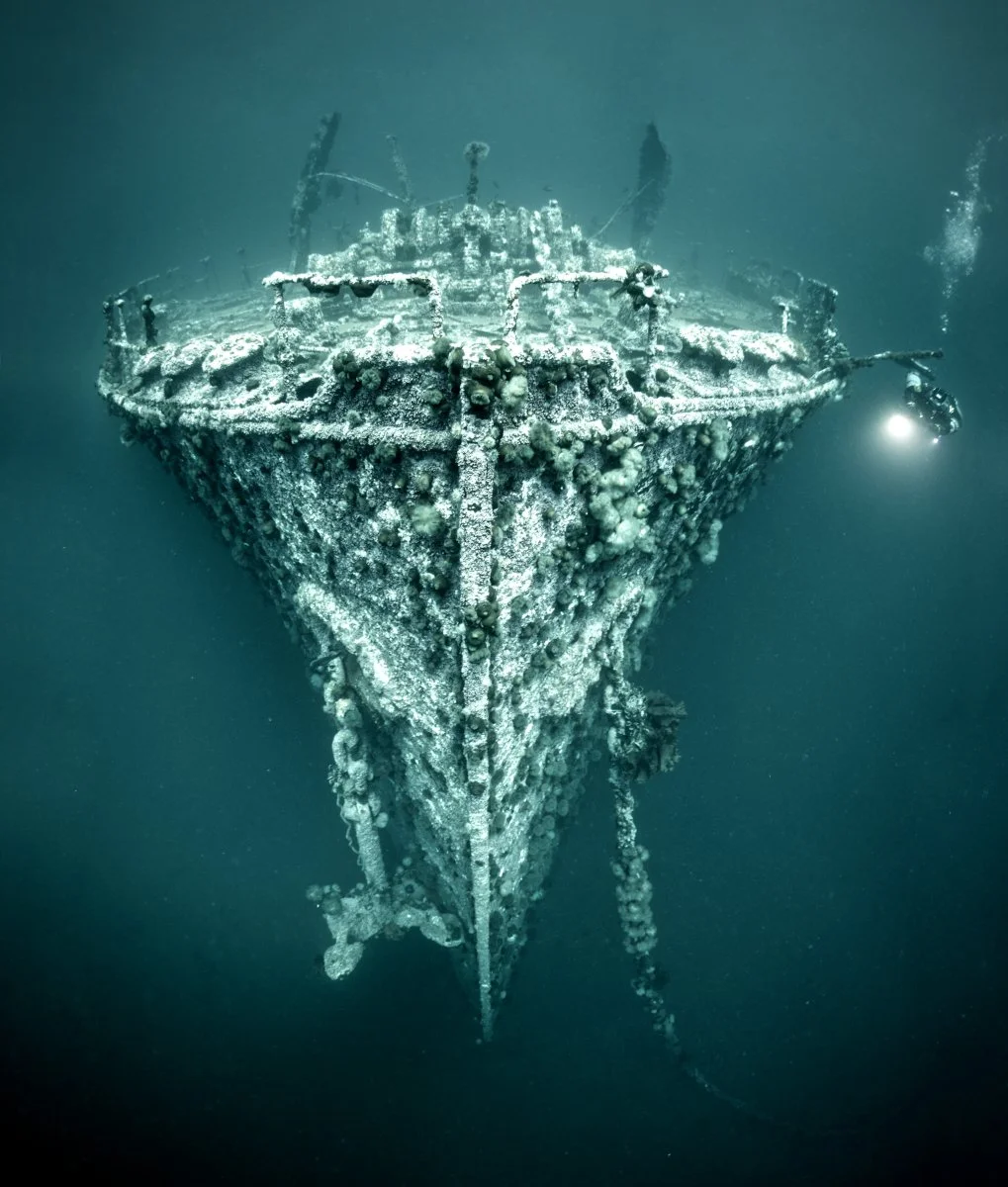
S.S. PLM-27 will be documented using both diver-based and AUV-based photogrammetry. To current knowledge, this project represents the first deliberate, coordinated application in Canada of both methods to the same shipwreck, undertaken as a comparative methodology and integrated into a single archaeological and cartographic product.
The wrecks lie at depths generally ranging from approximately 25 to 45 metres, allowing systematic documentation while supporting repeat surveys and long-term monitoring.
Scientific Objectives
The expedition integrates three complementary streams of research and documentation.
Underwater archaeology
High-resolution three-dimensional models will document wreck condition, spatial relationships, and archaeological context.
Industrial and subsurface heritage
Mine-diving photogrammetry will document flooded sections of the iron ore mine, capturing the industrial dimension of the wartime target.
Marine biology and ecology
The wrecks function as artificial reefs. Baseline ecological data will support longer-term monitoring of environmental change in Conception Bay.
Education, Outreach, and Legacy
The Virtual Memorial will support:
Marine Institute student orientation and field-science education
RCGS-developed educational resources for schools and post-secondary institutions
On-site visitor engagement through QR-code-enabled visualization
Heritage tourism development for Bell Island and Conception Bay
By transforming an otherwise inaccessible naval battlefield into an integrated digital landscape, the Bell Island Battle of the Atlantic Virtual Memorial Expedition provides a durable form of commemoration while advancing research, education, and public understanding. It preserves a nationally significant site and situates Bell Island within the wider Atlantic theatre that shaped the outcome of the Second World War.
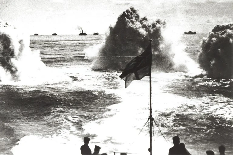
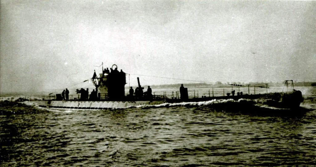
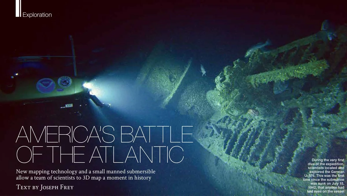
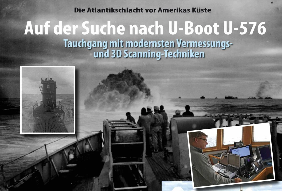
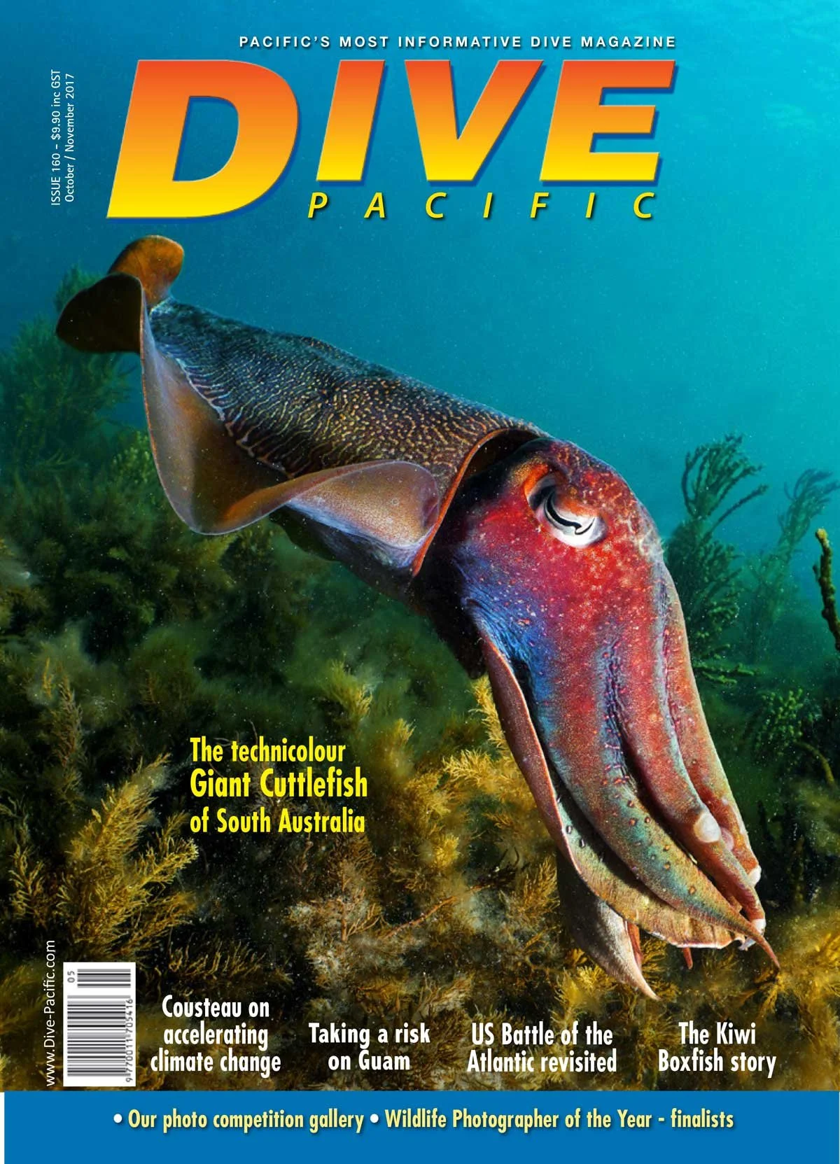
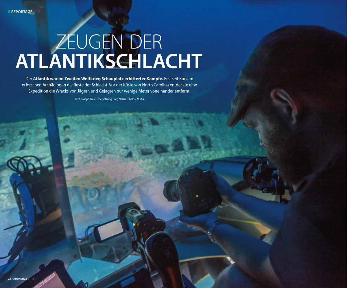
In 2016, I participated in NOAA’s Battle of the Atlantic Expedition documenting the German submarine U-576 and the merchant vessel Bluefields off North Carolina. That work contributed to the expansion of the Monitor National Marine Sanctuary, which now formally honours United States Navy and Merchant Marine personnel lost during the Battle of the Atlantic. The expedition combined advanced 3D photogrammetry, archival research, and survivor testimony to transform a seabed battlefield into a place of public memory and education.
Bell Island represents Canada’s most intact Second World War naval battlefield — a site where the naval engagement, the industrial target, and the commemorative landscape remain geographically connected. In 1942, four iron ore carriers were torpedoed at anchor adjacent to a defended harbour supplying steel production essential to the Allied war effort. The wrecks, coastal artillery battery, pier remains, mine infrastructure, and cemeteries together form the most concentrated and interpretable Battle of the Atlantic landscape in North America.
The Bell Island Battle of the Atlantic Virtual Memorial Expedition will integrate high-resolution underwater photogrammetry of the four wrecked merchant vessels with georeferenced terrestrial documentation of the Cemetery Hill battery, Scotia Pier remains, Lance Cove Seamen’s Cemetery, and Bell Island mine structures. These datasets will be spatially integrated within a unified GIS framework to produce a comprehensivethree-dimensional Digital Terrain Model of the 1942 submarine attack landscape — above and below the waterline.
Building on proven methodologies employed during NOAA’s 2016 expedition and subsequent Canadian-led HMCS Canada Expedition documentation project, the Bell Island initiative expands the scope to encompass an entire connected wartime industrial and naval system within Canadian waters.
The project will establish baseline archaeological documentation of the wrecks and a marine ecological baseline for Conception Bay. Together, this integrated dataset will support long-term heritage stewardship, academic research, graduate student training, curriculum-linked education, and the development of a nationally connected Battle of the Atlantic tourism framework linking Newfoundland to related sites across the province and mainland Canada — while providing a durable and dignified form of commemoration for those who served during the Second World War’s longest continuous battle.
Joseph Frey
Selected International Coverage of the 2016 NOAA Battle of the Atlantic Expedition
Authored by Joseph Frey and published in Canada, New Zealand, and Germany, these four articles document the 2016 NOAA Battle of the Atlantic Expedition and the 3D recording of U-576. The work reflects international recognition of the expedition’s archaeological significance and established a technological precedent for the digital battlefield mapping now proposed for Bell Island.